BAILII is celebrating 24 years of free online access to the law! Would you consider making a contribution?

No donation is too small. If every visitor before 31 December gives just £1, it will have a significant impact on BAILII's ability to continue providing free access to the law.
Thank you very much for your support!


BAILII [Home] [Databases] [World Law] [Multidatabase Search] [Help] [Feedback]

England and Wales High Court (Chancery Division) Decisions


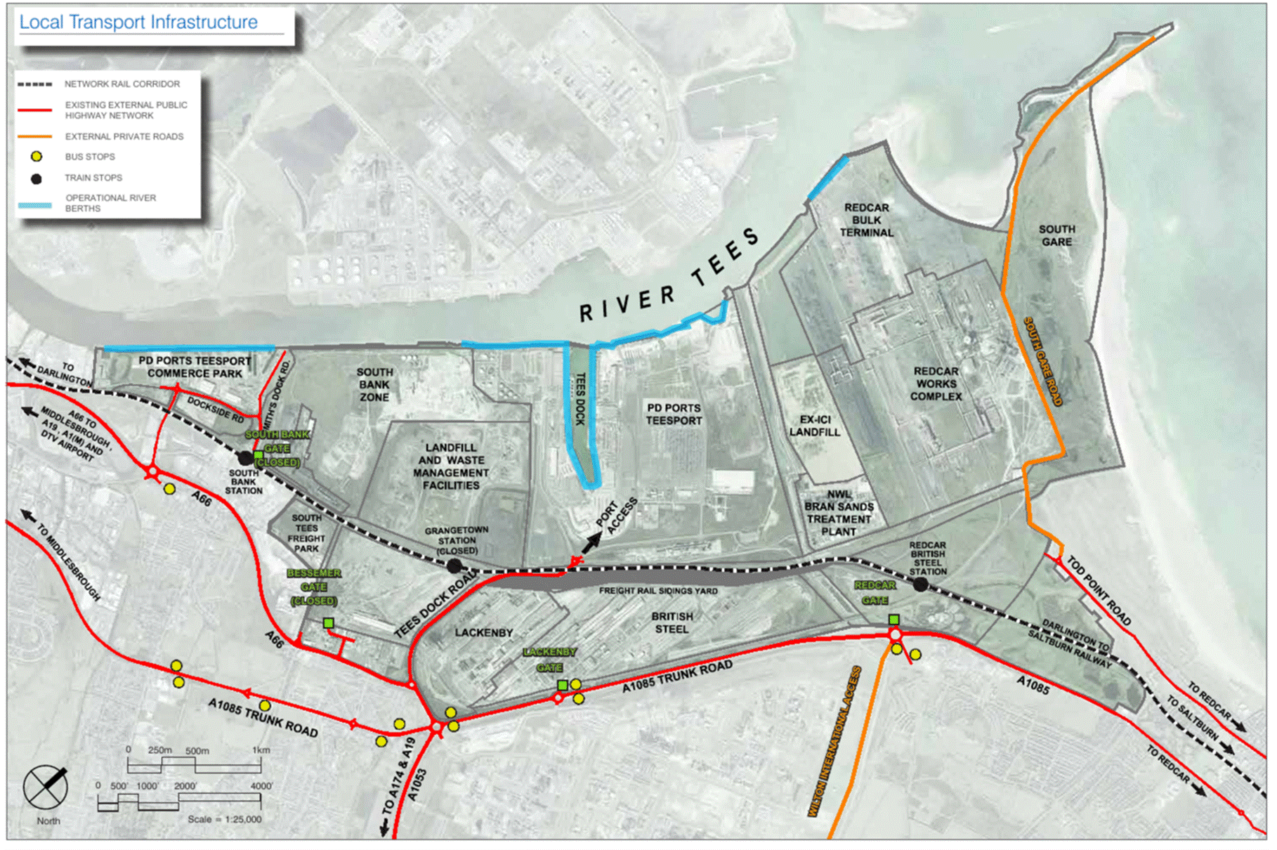
You are here: BAILII >> Databases >> England and Wales High Court (Chancery Division) Decisions >> South Tees Development Corporation & Anor v PD Teesport Ltd (Rev1) [2024] EWHC 214 (Ch) (05 February 2024)
URL: http://www.bailii.org/ew/cases/EWHC/Ch/2024/214.html
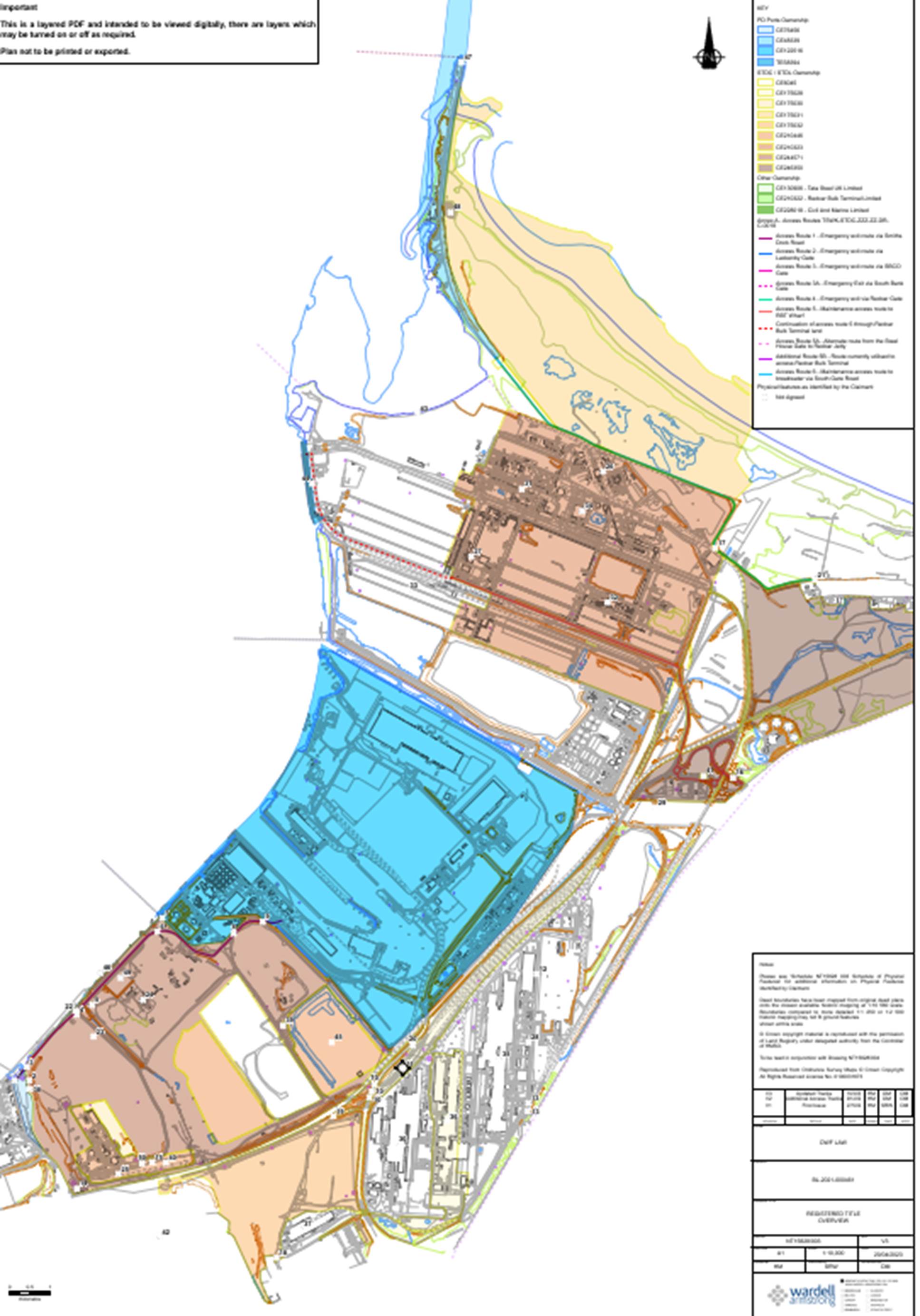
Cite as: [2024] EWHC 214 (Ch)

[New search] [Printable PDF version] [Help]


Neutral Citation Number: [2024] EWHC 214 (Ch)
Case No: BL-2021-000461

IN THE HIGH COURT OF JUSTICE
BUSINESS & PROPERTY COURTS OF ENGLAND & WALES
CHANCERY DIVISION (ChD)

Rolls Building, Royal Courts of Justice
Fetter Lane, London, EC4A 1NL
5 February 2024

B e f o r e :

MR JUSTICE RAJAH
____________________

Between:
(1) South Tees Development Corporation
(2) South Tees Developments Limited
Claimants
- and -

PD Teesport Limited Defendant
-and-

Teesworks Limited
Third Party

____________________

Zoë Barton KC and Daniel Petrides instructed by Forsters LLP for the Claimants
Andrew Walker KC and James Mitchell instructed by DWF Law for the Defendants
Katharine Holland KC and Admas Habteslasie instructed by Taylor Wessing LLP for the Third Party

Hearing dates: 3-6, 9-13, 16-20, 23-27, 30 October, 7, 9, 10 November 2023

____________________

HTML VERSION OF APPROVED JUDGMENT
____________________

Crown Copyright ©

    CONTENTS
        Page
    A. Introduction 4
    B. Overview of the Issues 7
    C. The Trial 9
    D. Approach to the Evidence 11
    E. Historical Context  
      The Port Authority 16
      Land reclamation and the breakwater 17
      Industry 17
    F. Easements – essential characteristics 18
    G. Capacity 19
    H. Express and Implied Rights of Way  
    H.1 Express and implied rights to access South Gare  
      South Gare and Access Route 6 21
      D's case – a compilation of rights from three deeds 23
      The challenge to D's ownership of South Gare 25
      The 1891 Deed – Fisherman's Crossing to Point C 28
      The 1925 Deed – Points A to B and Points B to C 30
      The 1974 Conveyance – a diverted route 34
      Conclusion 38
    H.2 Implied rights of access to Redcar Quay  
      Redcar Quay and Access Route 5 38
      D's case – implied rights in the 1971 Conveyance and the 1995 Lease 40
      1971 Conveyance – rights to give effect to intended purpose 41
      Discussion 42
      RBT 43
      Conclusion 44
    H.3 South Bank – express rights in Swan Hunter Conveyance 44
    H.4 South Bank - express rights under the 1964 Deed 46
    H.5 South Bank – implied rights under the 1964 Deed 48
    I. Prescription  
    I.1 The relevant law 50
      Use 51
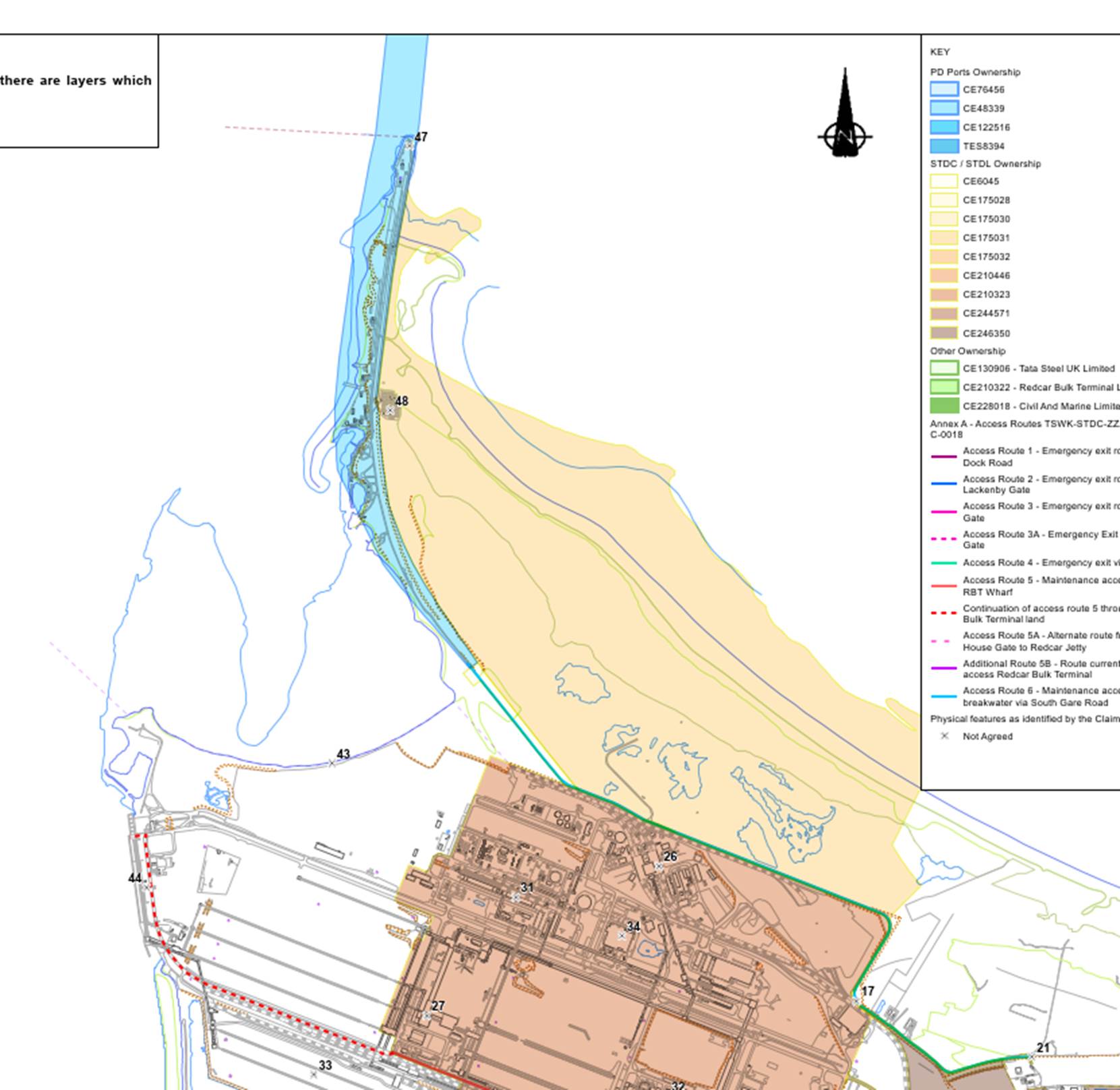
      Peaceable use (nec vi) 51
      Open use (nec clam) 52
      Without permission (nec precario) 52
      Length of use 53
      Burden of Proof 55
    I.2 Prescription – Access route 6 to South Gare  
      Use and period of use 55
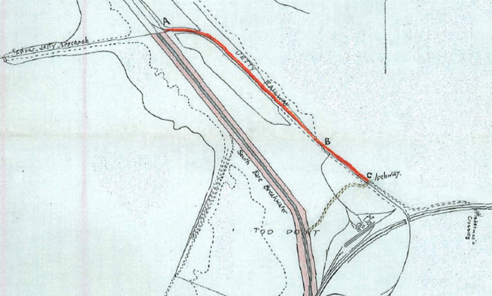
      Road closures 57
      Signage 58
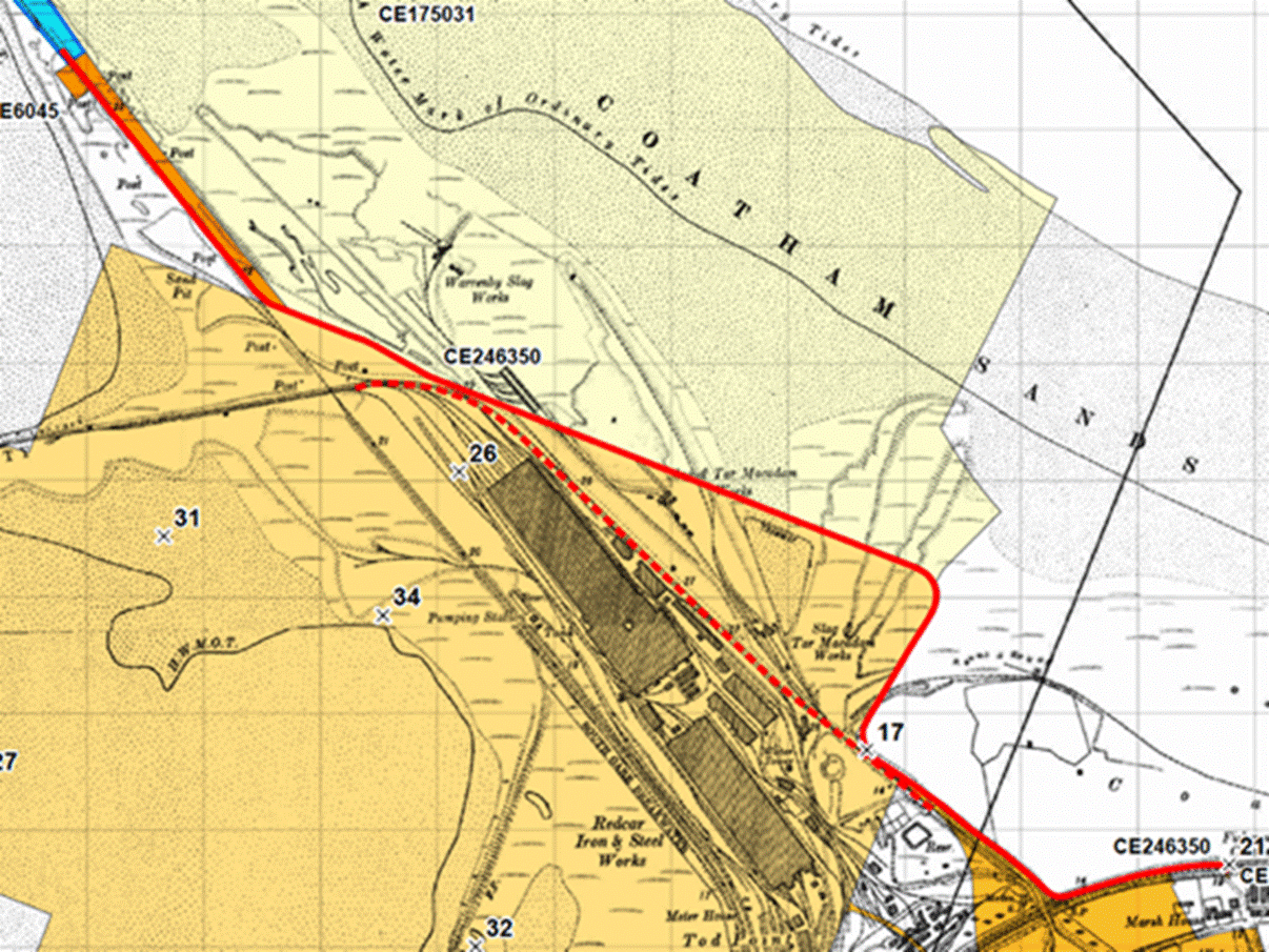
      Conclusion – Access Route 6 60
    I.3 Prescription – general use of Access route 1 across South Bank 60
      South Bank and Access Route 1 60
      Witnesses 62
      Use and period of use 63
      Steel beams and earth bund 65
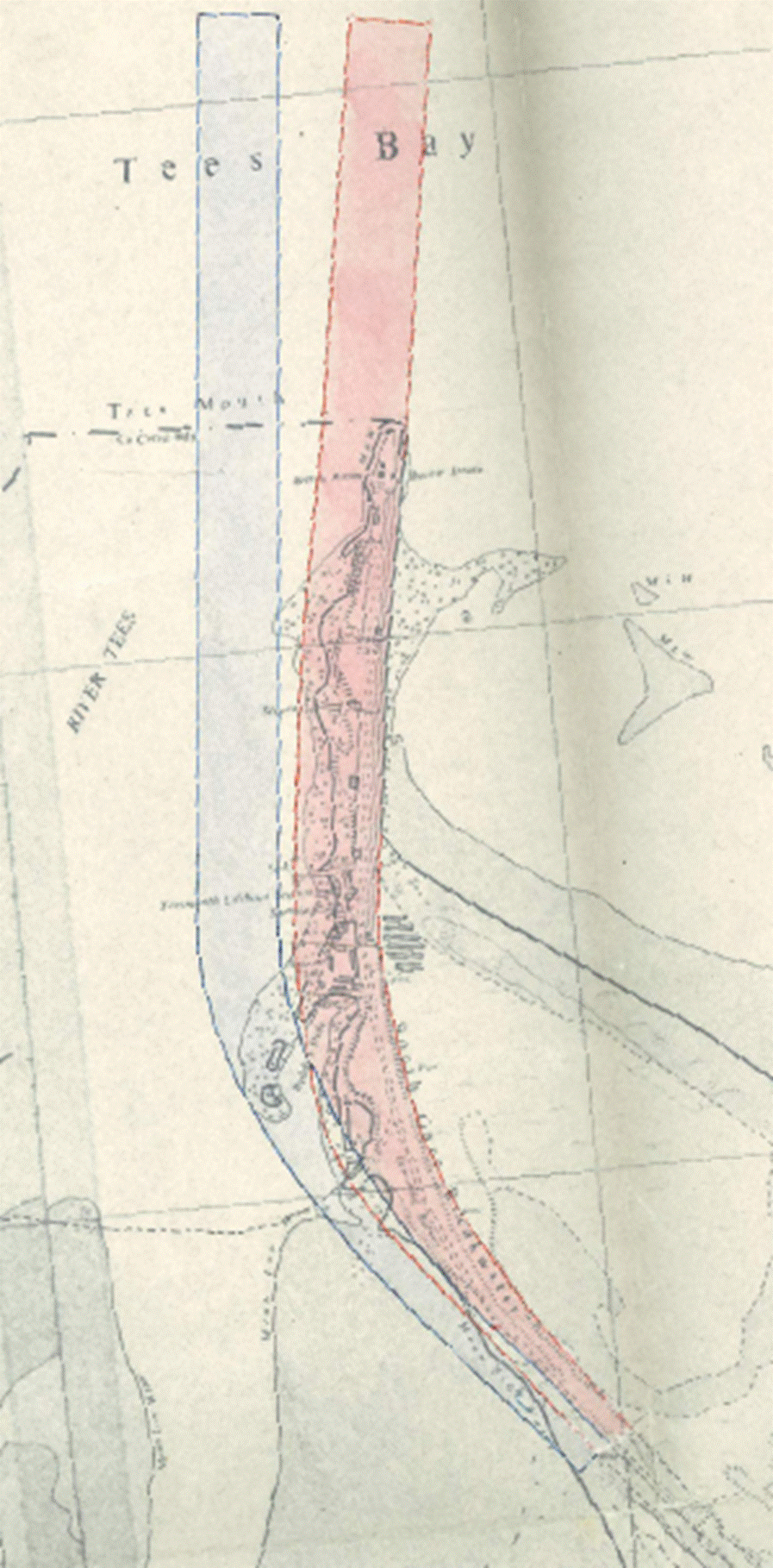
      Weighbridge 67
      Gates 67
      PCM Dispatch Post 68
      East Wharf gate 68
      Security generally 70
      Conclusions on use and period of use (South Bank) 72
      Statutory function of D 73
      Permission – the 1980 Licence 75
      Conclusion – prescription Access route 1 77
    I.4 Prescription – Emergency use of Access Route 1 across South Bank 78
    J. The Roundabout and Trespass 79
      Conclusion – trespass 87
    K. Proprietary estoppel 87
      The relevant law 87
      Witnesses 89
      The assurance 89
      Discussion 94
      Conclusion 96
    L Concluding remarks 96

    Mr Justice Rajah:

    A. INTRODUCTION

  1. This is a trial to determine the existence and extent of several rights of way that the Defendant ("D") claims to enjoy over the site of the former British Steel steelworks at Teesside, near Middlesbrough.
  2. The steel works were permanently closed in October 2015. The site now forms part of 4500 acres, which has been designated by central government as part of the UK's largest freeport. The area is said to be the largest brownfield development in Europe, and the development is expected to create up to 20,000 jobs for the local area.
  3. The first Claimant ("STDC") is a mayoral development corporation which was incorporated in August 2017, by statutory instrument to promote the regeneration of the area. The second Claimant ("C2"), is a wholly owned subsidiary of STDC which was incorporated in January 2019.  I refer to the two Claimants together as "Cs". The third party ("Teesworks") is a private company which is a joint venture vehicle. C's have a shareholding in Teesworks. JC Musgrave Capital Limited, Northern Land Management Limited and DCS Industrial Limited are the other shareholders in Teesworks. Teesworks has the benefit of options over land owned by Cs. Although separately represented, the interests of Cs and Teesworks in this litigation are entirely aligned. I shall refer to them together as "the STDC parties". The STDC parties are the freehold owners of the land over which D asserts rights of way.
  4. D is the statutory harbour authority for the River Tees, and owner and operator of the port of Teesport, one of the UK's major ports. D owns the land where the port is situated. D also owns Redcar Quay and it owns land, including the breakwater and lighthouse, at South Gare. It also owns a strip of land bordering the Smith's Dock Road ("the Smith's Dock Road Parcel").
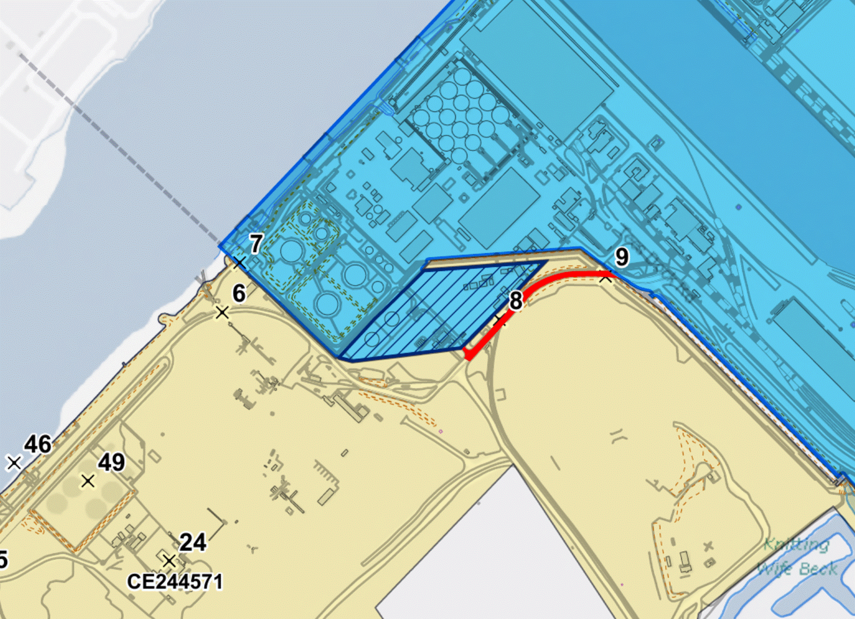
  5. D's land, and that of the STDC parties, forms part of the wider Teesside site ("the Site") which is located on the southern bank of the River Tees in the Borough of Redcar and Cleveland, approximately 3 miles from Middlesbrough and close to the towns of South Bank, Grangetown and Redcar. It broadly comprises of four areas known as South Bank, Redcar, Lackenby and South Gare, and abuts land owned by third parties (most notably Redcar Bulk Terminal Ltd ("RBT"). Fig 1 indicates the different areas' names within the Site and the public transport connections:
  6. Image 001

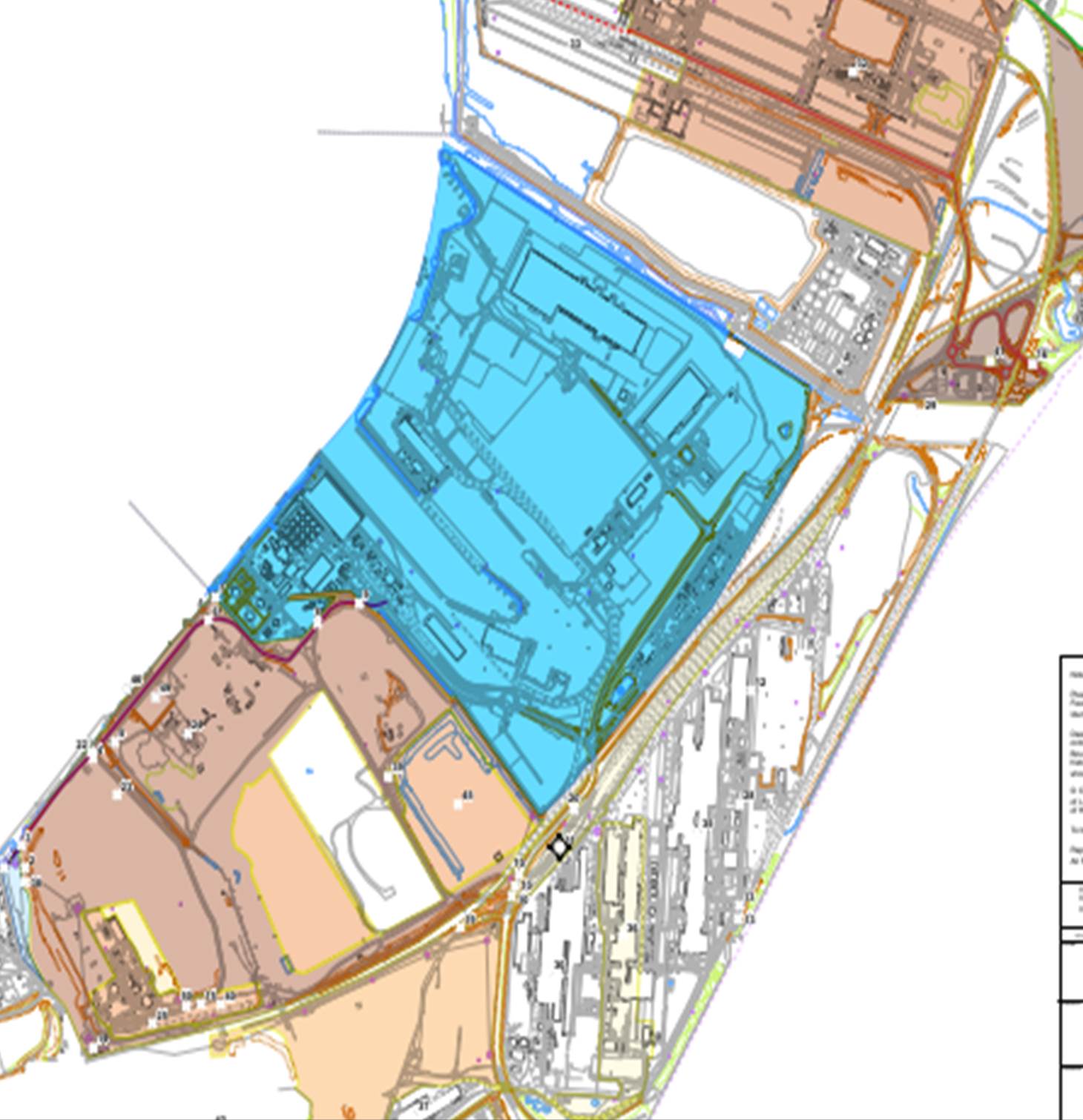
  7. The STDC parties' land is shaded in yellow and brown on the (north orientated) plan below (Fig 2). D's land is shaded blue. The white land belongs to third parties.
  8. Image 002

    B. OVERVIEW OF THE ISSUES

  9. Cs brought these proceedings seeking negative declarations that D does not enjoy any rights of way across their land. Following Teesworks' acquisition of part of Cs' land in October 2022, it was joined to the proceedings. D, by way of its Counterclaim, seeks positive declarations that it enjoys the benefit of rights of way across that land. D's Revised Schedule of Rights (served in July 2023) identified 15 separate categories of rights claimed, but in its trial skeleton argument D abandoned many of its claims to rights of way and has filed amended pleadings to reflect that. The STDC parties have lain down a marker that they intend to address the costs consequences of this late abandonment of part of D's case at an appropriate juncture. It is common ground that D, as the party seeking positive declarations as to the existence of those rights, bears the burden of proof in the proceedings.
  10. D's claims relate to three areas: South Gare, Redcar Quay and South Bank.
  11. D owns the breakwater at South Gare and maintains a lighthouse and other facilities there. The only road access to the breakwater and the lighthouse is along a solitary road, from the lighthouse to where it meets Tod Point Road at Fisherman's Crossing. The road is privately owned. The STDC parties own the road from Fisherman's Crossing to the point where it reaches D's land, and it is owned by D from that point until it ends at the lighthouse. D claims to be entitled to a right of way for all purposes and with vehicles across the STDC's section of the road. In these proceedings, this road has been called "Access Route 6". D's claim is that it has an express right of way granted to it in various conveyances dating back to 1891, and that although the route may have moved or been diverted, it retains a right of way over Access Route 6. In the alternative, D says that it has a prescriptive right arising under the common law from long user.
  12. D also owns Redcar Quay. This is a bulk ore terminal constructed in the early 1970's which is currently leased to RBT. Redcar Quay has access from the River Tees but is otherwise landlocked. Road access to a highway (the A1085) must cross over land owned by RBT and land owned by the STDC parties – this is Access Route 5. D says that the grant of a right of way is implicit in the conveyance to it in 1971, or under a 1995 lease, but if it is wrong on that then it claims a right of way by necessity under the common law.
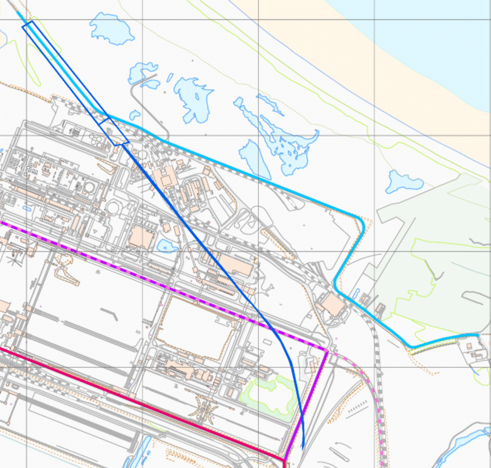
  13. D owns Teesport. The primary access to Teesport is via the Tees Dock Road which connects Teesport to the A66 and the A1065. Tees Dock Road is susceptible to flooding. D claims a right of way along a riverside road, which connects D's land by the highway at Smith's Dock Road (the Smith's Dock Road Parcel shaded light blue in the bottom left-hand corner of Fig 2) to the Tees Dock Road on D's land at Teesport. This is Access Route 1. D claims a right of way by prescription under the common law arising from long user for general purposes, and separately for emergency access and egress when Tees Dock Road cannot be used.
  14. In relation to Teesport, D also claims a right of way under the doctrine of proprietary estoppel. In order to secure D's agreement to the building of a roundabout which D says encroaches on its land, D alleges it was assured by STDC that it would be granted a suitable alternative access route through the STDC parties' land at South Bank and it has acted to its detriment as a consequence.
  15. The STDC parties say a complete answer to this claim is that D's predecessor in title did not have the statutory capacity to acquire easements; they seek to amend to plead that point. D opposes the proposed amendment only on the ground that it is without merit and so at the outset of the trial, I directed that submissions on the issue should be made as part of closing submissions and for the application to amend to be considered alongside the other issues for determination in this Judgment.
  16. Subject to that issue, the STDC parties dispute D's contentions that it has express or implied rights arising from the conveyances as a matter of their proper construction and the law.
  17. As for prescription, the STDC parties say that D cannot discharge the burden of proof on it in respect of any of its claims. In the alternative, they assert that any period of established use was with the permission of one of them or their predecessors in title or was interrupted by a period of such permissive use.
  18. C. THE TRIAL

  19. The trial was ordered to be expedited. It commenced on 3 October 2023 and lasted for approximately 6 weeks. Unfortunately, attempts to find an available courtroom in Middlesbrough or Newcastle proved unsuccessful, with the consequence that the trial was heard in the Rolls Building in London. Some 34 witnesses, most of them from Middlesborough or the area around it, travelled down to London to give their evidence. Three witnesses – aged 91, 79 and 79 - gave evidence remotely by video conference. I travelled to Middlesbrough to visit the site with representatives of the parties after the trial.
  20. I heard evidence from two expert witnesses. Mr David Meddings, a chartered land surveyor, gave evidence for the D and Mr Martin Clay, an architect, gave evidence for the Cs. The purpose of their evidence was twofold. Firstly, they provided assistance in the interpretation of contemporaneous documents like aerial photographs and prepared a series of maps and plans showing the present and historical position of title to the land, the routes claimed, and the physical features thought to be relevant. Secondly, they gave their expert opinion on whether the roundabout encroached on D's land.
  21. The following witnesses of fact were called by D:
  22. 18.1. Leonard Tabner
    18.2. Ian Turner
    18.3. Paul Thatcher
    18.4. Alan Daniels
    18.5. Bernard Meynell
    18.6. Michael Westmoreland
    18.7. Michael McConnell
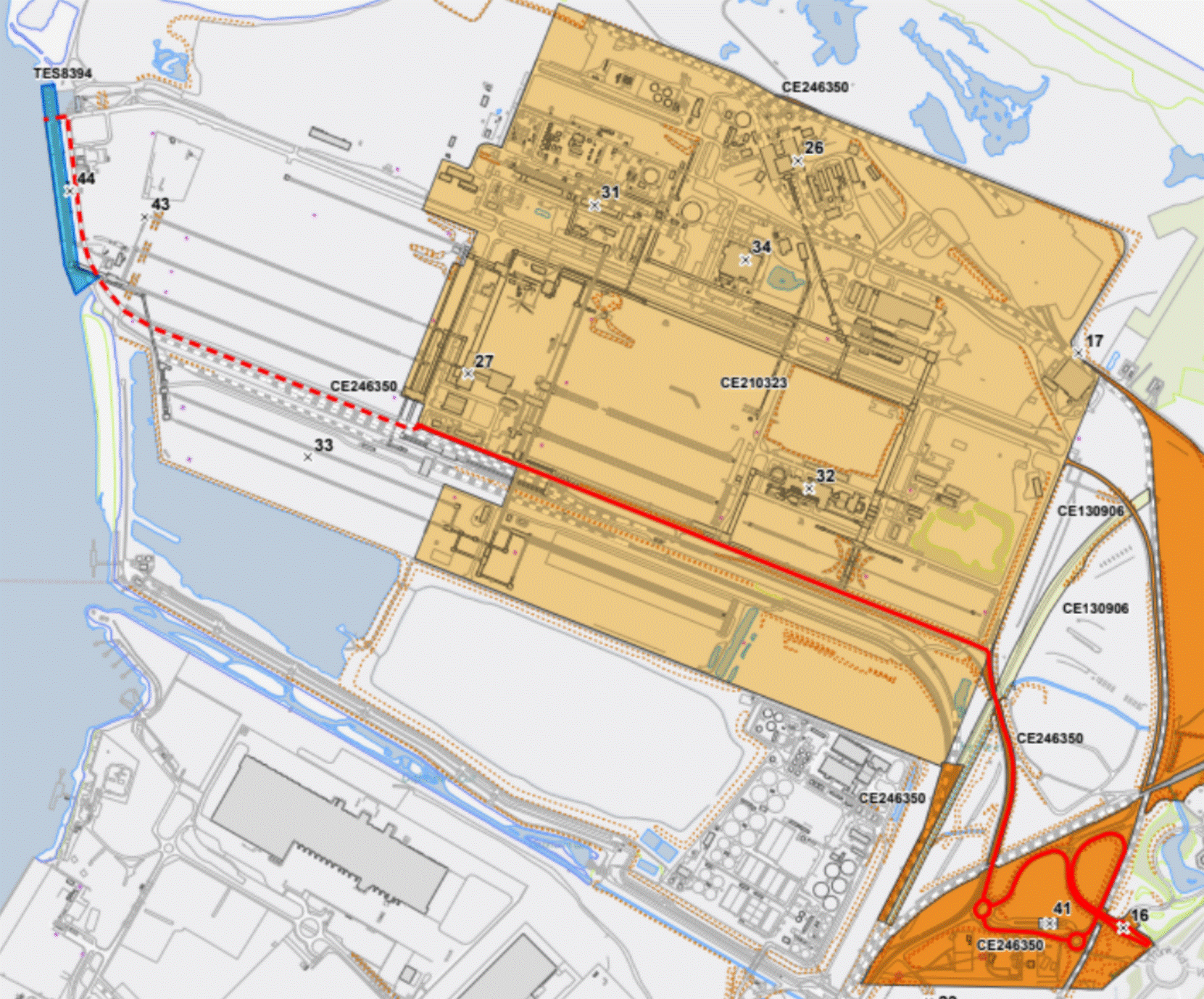
    18.8. Jeremy Hopkinson
    18.9. Joseph Wilson
    18.10. Brian Dresser
    18.11. Paul McGrath
    18.12. Peter Johnston
    18.13. Michael Robinson
    18.14. Paul Grainge
    18.15. Alfred Brian Bainbridge
    18.16. Patrick Taylor
    18.17. Keith Overfield
    18.18. Peter McWilliams
    18.19. David Varey
    18.20. Allan Duncan
    18.21. Matthew Warburton
    18.22. Neil Dalus
  23. The following witnesses of fact were called by Cs.
  24. 19.1. Julie Gilhespie
    19.2. Chris Harrison
    19.3. Neil Thomas
    19.4. John McNicholas
    19.5. Robert Norton
    19.6. David Jones
    19.7. Christopher Briggs
    19.8. Andy Pickford
    19.9. Clive Donaldson
    19.10. Colin Agar
    19.11. Mark Buttita
    19.12. Paul Booth
    19.13. Karl Dickinson
  25. Teesworks called no witnesses, but relied on the evidence called by Cs.
  26. In relation to the documentation, there were hundreds of deeds, conveyances, office copy entries and other conveyancing documentation, hundreds of historic plans and maps (conveyancing plans, site plans prepared by British Steel or its predecessors, Ordnance Survey maps over the last hundred years), and nearly as many interpretive plans prepared by the experts. There were historic photographs, including aerial photographs and publicly available reports, books and other publications. There were also contemporaneous communications between the parties and internal documentation the bulk of which related to the roundabout and promissory estoppel issues.
  27. Notwithstanding the vast number of documents in the electronic bundles, it is also clear that I do not have all relevant documents. As appears below in relation to trespass, there are important deeds and plans which are missing. During the course of the trial, it became clear that there is a cabinet system of about 300,000 plans in the possession of British Steel. Although STDC has a licence to access that cabinet system, and some plans were produced from it, a proper search has not been conducted for the purposes of disclosure. There is also a general dearth of internal communications or inter party communications prior to 2002, about D's use of Access Route 1 for emergency use and generally. There is no documentary record of the discussions, which must inevitably have taken place between the THPA and British Steel at the time the road to South Gare was diverted to accommodate the new Redcar steelworks. These are just examples of the gaps in the documentary record. I have to do my best to identify what reliable conclusions can be drawn from this incomplete universe of documents.
  28. D. APPROACH TO THE EVIDENCE

  29. Most of the factual witnesses were called to give evidence on the disputed issues of prescription. In the main, these were patently honest witnesses doing their best to assist the court. However, it is clear that they cannot all be correct because there are countless inconsistencies between their recollections. Memory plays tricks on people. It is perfectly possible for an honest witness to have a firm memory of events which they believe to be true, but which in fact is not correct.
  30. The well known, and even now, most comprehensive, judicial treatment of the science, is by Mr Justice Leggatt (as he then was) in Gestmin SGPS SA v Credit Suisse (UK) Ltd [2013] EWHC 3560 (Com m), at paragraphs 15-20.
  31. "15. An obvious difficulty which affects allegations and oral evidence based on recollection of events which occurred several years ago is the unreliability of human memory.
    16. While everyone knows that memory is fallible, I do not believe that the legal system has sufficiently absorbed the lessons of a century of psychological research into the nature of memory and the unreliability of eyewitness testimony. One of the most important lessons of such research is that in everyday life we are not aware of the extent to which our own and other people's memories are unreliable and believe our memories to be more faithful than they are. Two common (and related) errors are to suppose: (1) that the stronger and more vivid is our feeling or experience of recollection, the more likely the recollection is to be accurate; and (2) that the more confident another person is in their recollection, the more likely their recollection is to be accurate.
    17. Underlying both these errors is a faulty model of memory as a mental record which is fixed at the time of experience of an event and then fades (more or less slowly) over time. In fact, psychological research has demonstrated that memories are fluid and malleable, being constantly rewritten whenever they are retrieved. This is true even of so-called 'flashbulb' memories, that is memories of experiencing or learning of a particularly shocking or traumatic event. (The very description 'flashbulb' memory is in fact misleading, reflecting as it does the misconception that memory operates like a camera or other device that makes a fixed record of an experience.) External information can intrude into a witness's memory, as can his or her own thoughts and beliefs, and both can cause dramatic changes in recollection. Events can come to be recalled as memories which did not happen at all or which happened to someone else (referred to in the literature as a failure of source memory).
    18. Memory is especially unreliable when it comes to recalling past beliefs. Our memories of past beliefs are revised to make them more consistent with our present beliefs. Studies have also shown that memory is particularly vulnerable to interference and alteration when a person is presented with new information or suggestions about an event in circumstances where his or her memory of it is already weak due to the passage of time.
    19.The process of civil litigation itself subjects the memories of witnesses to powerful biases. The nature of litigation is such that witnesses often have a stake in a particular version of events. This is obvious where the witness is a party or has a tie of loyalty (such as an employment relationship) to a party to the proceedings. Other, more subtle influences include allegiances created by the process of preparing a witness statement and of coming to court to give evidence for one side in the dispute. A desire to assist, or at least not to prejudice, the party who has called the witness or that party's lawyers, as well as a natural desire to give a good impression in a public forum, can be significant motivating forces.
    20. Considerable interference with memory is also introduced in civil litigation by the procedure of preparing for trial. A witness is asked to make a statement, often (as in the present case) when a long time has already elapsed since the relevant events. The statement is usually drafted for the witness by a lawyer who is inevitably conscious of the significance for the issues in the case of what the witness does nor does not say. The statement is made after the witness's memory has been 'refreshed' by reading documents. The documents considered often include statements of case and other argumentative material as well as documents which the witness did not see at the time or which came into existence after the events which he or she is being asked to recall. The statement may go through several iterations before it is finalised. Then, usually months later, the witness will be asked to re-read his or her statement and review documents again before giving evidence in court. The effect of this process is to establish in the mind of the witness the matters recorded in his or her own statement and other written material, whether they be true or false, and to cause the witness's memory of events to be based increasingly on this material and later interpretations of it rather than on the original experience of the events."
  32. Since those comments were made, CPR PD57AC has been introduced in the Business and Property Courts. It requires witness statements in most Business and Property cases to be prepared in accordance with the Statement of Best Practice which is annexed to it. There is a similar warning to that in Gestmin to be found at paragraph 1.3:
  33. "Witnesses of fact and those assisting them to provide a trial witness statement should understand that when assessing witness evidence the approach of the court is that human memory:
    (1) is not a simple mental record of a witnessed event that is fixed at the time of the experience and fades over time, but
    (2) is a fluid and malleable state of perception concerning an individual's past experiences, and therefore
    (3) is vulnerable to being altered by a range of influences, such that the individual may or may not be conscious of the alteration."
  34. The Statement of Best Practice is intended to guide the preparation of witness statements in line with the science, particularly as to how to access recollections without interfering with them. The rules for examination in chief do not allow leading questions or free use of documents to "refresh memory" and the science suggests examination in chief was a good model for accessing a witness' recollection without corruption. In broad terms, the Statement of Best Practice encourages the preparation of a witness statement in a way which follows the template of an examination in chief:
  35. 1. the interviewer should ask open questions as far as possible;
    2. the interviewer should not ask leading questions as far as possible;
    3. the witness should not be shown documents except those documents which could be shown to a witness to refresh memory in examination in chief (i.e. a document created or seen by the witness at an earlier point in time while the facts evidenced by or referred to in the document were still fresh in their mind); and
    4. the preparation of a trial witness statement should involve as few drafts as practicable.
  36. All of the witness statements in this case profess to have been made in accordance with CPR PD57AC. The extent to which I consider the Statement of Best Practice has been complied with in respect of each witness, is something which I consider when assessing their evidence. It must be said, however, that even religious compliance with the Statement of Best Practice does not remove the risk of interference with memory.
  37. D criticises Cs, with some justification, as to the extent to which they have complied with CPR PD57AC. For example, Christopher Briggs was interviewed with Noel Kelly. Noel Kelly did not give evidence. Although the witness statement sets this out openly, it is not what the Statement of Best Practice envisages. The witness statement does not say, as Mr Briggs said in cross examination, that he had been approached to give evidence by David Jones who was also present during the interview. Mr Brigg's witness statement was not solely his evidence, but included words and recollections from others. It was a combined effort, and it fails to identify what are his own recollections, or prevent his recollections being interfered with by discussion with others. Like many of Cs witnesses, Mr Briggs was shown documents which would not have satisfied the test for refreshing memory, including the "Out of Gauge" plan, which (as I explain below) is misleading. While I am completely satisfied that he was an honest witness, his witness statement simply did not comply with CPR PD57AC, or its objectives, notwithstanding the purported certificate of compliance. Ms Barton submitted that this non-compliance was unfortunate but not particularly relevant as I had heard the evidence and seen it tested. I disagree for the reasons I have sought to explain above. The manner in which the recollections of honest witnesses are accessed does matter because it can change the recollections of those witnesses without them realising it.
  38. I also formed the view that David Jones was not being open and transparent about the preparation of his evidence. In his evidence, he admitted being contacted by Mr Musgrave and Mr Corney (who are the individuals behind Teesworks) and for whom he does work, to give evidence. He said that he nevertheless did not have any conversations with anyone about his evidence, apart from Forsters, before he prepared his statement. It later transpired that he had contacted Mr Briggs and Mr Kelly and persuaded them to give evidence, and indeed attended at Cs premises with them and was present when Forsters took instructions for their evidence. He had also seen the "Out of Gauge" plan before he made his witness statement – his explanation that he must have seen it lying around when he was involved in removing papers from the Site for the Official Receiver and remembered it because he had a "snapshot memory" was not credible. I consider it more likely, that someone provided Mr Jones with the "Out of Gauge" plan as part of discussions about his evidence. I noticed that his evidence improved through cross-examination, correcting, and expanding, on what was said in his witness statement. While I do not disregard his evidence, I treat it with caution.
  39. Although Legatt J's words have been sometimes taken as an encouragement to place no reliance on witness recollection, particularly when there is an abundance of reliable contemporaneous documentation, the Court of Appeal has confirmed that the assessment of the credibility of a witness' evidence should be a part of a single compendious exercise of finding the facts based on all of the available evidence; see Kogan v Martin [2019] EWCA Civ 1645 and Natwest Markets Plc, Mercuria Energy Europe Trading v Bilta (UK) Ltd (In Liquidation) [2021] EWCA Civ 680 at paragraphs 50 and 51.
  40. Each witness's evidence has to be weighed in the context of the reliably established facts (including those which can safely be distilled from contemporaneous documentation bearing in mind that the documentation itself may be unreliable or incomplete), the motives and biases in play, the possible unreliability or corruption of human memory and the inherent probabilities. Where there is reliable contemporaneous documentation, it will be natural to place weight on that. Where documents add little to the analysis, other secure footholds in the evidence need, if possible, to be found to decide whether it is more likely than not that the witness' memory is reliable or mistaken.
  41. That is the approach I take.
  42. E. HISTORICAL CONTEXT

    The Port Authority

  43. The Tees Conservancy Commissioners ("the TCC") was a statutory body formed by the Tees Conservancy and Stockton Dock Act 1852, which inherited the duties of the old Tees Navigation Company. 
  44. The TCC was replaced by the Tees and Hartlepool Port Authority ("the THPA"), which was created by the Tees and Hartlepools Port Authority Act 1966 ("the 1966 Act") .  
  45. A private limited company, the Tees and Hartlepool Port Authority Ltd, was incorporated on 2 August 1991 with the power to acquire the property, rights and functions of the THPA pursuant to s.2 of the Ports Act 1991. On 1 April 2003, this new company changed its name to that of D.  
  46. In this Judgment, I refer to D, the THPA and the TCC together as "D and its predecessors".
  47. D is a privately owned company with commercial profit-making objectives. It also has a statutory function. The statutory powers and duties of D and its predecessors include:
  48. 37.1. A duty to maintain and manage the port and waterways, and broad powers conferred for that purpose: see e.g. Part III of the 1966 Act.
    37.2. The power to operate a police force.  Originally founded pursuant to the Harbour, Docks and Pier Clauses Act 1847, the Tees Harbour Police now operate pursuant to s.103 of the 1966 Act, which provided that the THPA could continue and maintain the police force maintained by the TCC and that its members "shall have all the powers and privilege, and shall be entitled to the indemnities and protection, of a constable within the harbour and in any place not more than two miles beyond the limits of the harbour".
    37.3. Under the Pilotage Act 1987, the power to regulate the provision of pilotage services within the harbour.

    Land reclamation and the breakwater

  49. Historically, much of the Site formed part of the riverbed or the foreshore of the estuary of the River Tees. Prior to the Victorian period, even above the high water-mark, much of the relevant land consisted of marshes, sands and mudflats unsuitable for construction or industry. That land has been reclaimed from sea, river and marsh by work done by, or under the auspices of the TCC.
  50. A 2 ½ mile long breakwater was built by the TCC, with a railway line along it. It was formally opened in 1888. A lighthouse and coastguard station were established at its furthest reaches at South Gare. Much of the breakwater has now been incorporated into land reclaimed on either side, but there still remains the last section of it leading to the lighthouse at South Gare.
  51. The Newcomen family was a prominent family in the area and were significant landowners. Trustees and entities holding that land are involved in many of the conveyances in this case. For convenience, the parties have referred to them as "the Newcomen Estate".
  52. Industry

  53. By 1912, there were two main industries at the Site – shipbuilding and steelmaking.
  54. The shipbuilder Smith's Dock Company opened a major ship-building yard in 1909, on the western side of Smith's Dock Road roughly where the Teesport Commerce Park is now located. In 1966 Smith's Dock Company merged with another local shipbuilder, Swan Hunter & Wigham Richardson ("Swan Hunter"). The ship-building yard remained in active use until its closure in 1987.
  55. As for steelmaking, a collection of iron works in the area came to be replaced by a succession of major iron and steel manufacturers. By 1865, Bolckow, Vaughan & Co ("Bolckow Vaughan") was producing 1 million tons of pig iron per annum from its factories in the area. It acquired another major manufacturer, Walker Maynard & Co in in 1916 before it was itself eventually subsumed by Dorman, Long & Co ("Dorman Long") which employed 20,000 people in the area in 1914 and opened major new steelworks on the Site. The Iron and Steel Act 1967 brought the fourteen largest steel producers in the UK, including Dorman Long, into public ownership as the British Steel Corporation ("British Steel"). By this point, Dorman Long owned all the land now owned by Cs at the Site and it was vested in British Steel by statutory instrument in 1970.
  56. Following the nationwide steel strike in 1980 and acceleration of de-industrialisation over that decade, the steel industry on Teesside entered a period of steady decline. In 1999, British Steel (now re-registered as British Steel Ltd) merged with the Dutch steel producer, Koninklijke Hoogovens, and was renamed Corus UK Ltd in 2000 ("Corus"), under whose ownership the Teesside steel operations were mothballed. Corus Group was then acquired in 2007 by the Tata Group, with the effect that Corus was renamed Tata Steel UK Limited ("Tata") in 2010. Shortly thereafter in 2011, parts of Tata's holdings were sold to Sahaviriya Steel Industries Limited ("SSI"), the rest being acquired by Cs in 2019. SSI recommenced steelmaking in around 2012 and operated the Redcar Steelworks, South Bank Coke Ovens and Lackenby works for some time. However, following SSI's insolvency in October 2015 the steelworks were permanently closed.
  57. In this Judgment, I will refer to STDC and its relevant predecessor in title to the land, namely British Steel which became Corus and then Tata, as "the STDC predecessors".
  58. F. EASEMENTS – essential characteristics

  59. An easement is a right a landowner has to use land owned by another (or to prevent it being used), in a particular way. It is an incorporeal hereditament, and therefore a species of land itself. Unlike a personal right (such as a licence), an easement attaches to the land it benefits and the benefit and burden of the easement passes to successors in title to the original parties.
  60. The essential characteristics of an easement were identified in the Judgment of Evershed MR in the leading case of Re Ellenborough Park [1956] Ch 131 (and recently approved by the Supreme Court in Regency Villas Ltd v Diamond Resorts Ltd [2018] UKSC 57; [2019] AC 553):
  61. 47.1. There must be a 'dominant tenement' (i.e. land which enjoys the benefit of the easement) and a 'servient tenement' (i.e. land over which the easement is exercised); an easement cannot exist 'in gross'.
    47.2. The right must 'accommodate' (i.e. benefit) the dominant land. The right must be of some practical importance to the dominant tenement, as being of benefit and utility to its normal use and enjoyment. The dominant land does not need to neighbour the servient land, but it needs to be close enough to the dominant land to confer a practical benefit on it.
    47.3. There must be diversity of ownership, such that the dominant and servient land must be owned by different persons. If the dominant and servient land come into common ownership, any easement will be permanently extinguished.
    47.4. The right must be one which is capable of forming the subject matter of a grant.

    G. CAPACITY

  62. The STDC parties seek permission to amend to raise as a defence to D's claims that between 1 November 1966 and 31 July 1991, THPA did not have the capacity to acquire easements. It is contended that this lack of capacity prevented the THPA acquiring easements by express or implied grant, and further it prevented prescriptive rights arising.
  63. There is no dispute that the TCC (the THPA's immediate predecessor) had capacity to acquire easements nor that any easements the TCC had were vested in the THPA. There is also no dispute that D has the capacity to acquire easements.
  64. The STDC parties contend that, unlike the statutes constituting the TCC and D, the 1966 Act which established the THPA, contains no express powers to acquire easements by agreement. It is not suggested there was a reason for removing from the THPA the power to acquire easements by agreement, but it is contended that this is the consequence as a matter of statutory construction.
  65. The TCC's powers were set out in various Tees Conservancy Acts. An express power to "purchase, but by Agreement only…any Rights of Way or other Easements over [Land adjoining or near to the Tees]" was provided for by section 11 of the Tees Conservancy Act 1863. Section 23 of the Tees Conservancy Act 1867 empowered the Commissioners to acquire by agreement "any Easement, Right, or Interest in or affecting any Lands" which may be required for certain works. Section 9 of the Tees Conservancy Act 1875 provided that persons empowered by the Land Clauses Act to sell or convey certain lands could "grant to the Commissioners any easement …".
  66. The preamble to the 1966 Act explains that the THPA was being created to consolidate the entire undertaking of the TCC, the Hartlepool Commissioners, the Docks Board, and the entities operating Stockton Quay and Middlesbrough Wharf. By section 12, the THPA was given the duty to take such steps as it considered necessary for the conservancy, maintenance and improvement of the harbour and its facilities and for the reclamation of land. For that purpose, it was given the power (section 12(2)(d)) to "do all other things which in their opinion are expedient to facilitate the proper carrying on or development of the undertaking".
  67. By section 14(1), the THPA was given the power to "acquire land by agreement, whether by way of purchase, exchange, lease or otherwise" (emphasis added). By section 14(3), the THPA was given the power to "dispose of land…in such manner, whether by way of sale, exchange, lease, the creation of any easement, right or privilege or otherwise, for such period, upon such conditions and for such consideration as they think fit".
  68. Pausing there, if the question of construction stopped there, I would be inclined to accept that in the context of the permissive empowerment of section 12, section 14(1) was wide enough to permit the THPA to acquire interests in land including easements. This is reinforced by the fact that s. 14(3) is wide enough to permit the THPA to acquire an easement by reservation on a disposal of land. But the matter does not stop there.
  69. The 1966 Act (section 4(1)) incorporates s.3 of the Harbours, Docks and Piers Clauses Act 1847, which defines "land" as including "hereditaments". The 1847 Act was one of a series of acts consolidating clauses and terms usually contained in other statutes. The Land Clauses Consolidation Act 1845 was another such act, section 3 of which also defines "land" as including hereditaments. Hereditaments was authoritatively determined to include incorporeal hereditaments, such as easements, in Great Western Railway v Swindon and Cheltenham Extension Railway Co (1884) 9 App Cas 787 at 795, 800-803 and 807-809. In doing so, the House of Lords distinguished the obiter remarks in the Court of Appeal of Lord Carnworth in Pinchin v London and Blackwall Railway Company (1854) 43 E.R. 1101.
  70. I am satisfied therefore, that there is no merit in the contention that the THPA did not have the power to acquire easements by agreement and therefore no merit in the proposed amendments. I dismiss the applications.
  71. H. EXPRESS AND IMPLIED RIGHTS OF WAY

    H.1 Express and implied rights to access South Gare

    South Gare and Access Route 6

    Image 003

    Fig 3
  72. The land at South Gare which is owned by D ("South Gare"), is shaded light blue on the plan above and extends out to sea. Its principal feature is what remains of a narrow breakwater some two-and-a-half miles long, formed by the tipping of millions of tons of slag from local ironworks. Construction began in the 1860s and it was completed in 1888. At its end is sited a lighthouse.   
  73. The area to the east, shaded yellow, belongs to the STDC parties. It is largely undeveloped and is now protected as a Site of Special Scientific Interest under the Wildlife & Countryside Act 1981.  There is a group of fisherman's cabins on the STDC parties' land which are licensed out.
  74. Access by road to South Gare has at all material times started at a point called Fisherman's Crossing (marked 21 on the bottom right corner of Fig 3).  When the Redcar Steelworks (shaded brown on Fig 3) were constructed in the 1970s, a new section of road was constructed, which followed the perimeter of the new Redcar Steelworks. This road from Fisherman's Crossing to South Gare is Access Route 6, shown in green on the plan above. Although what is now Access Route 6 first appears on Ordnance Survey mapping in 1980, it is clear enough from an aerial photograph from November 1974 that it was in place on the ground by then.
  75. D's case - a compilation of rights from three deeds

  76. D's case is that by a combination of three deeds, it has a complete right of way between Fisherman's Crossing and South Gare along Access Route 6. The three deeds are:
  77. 60.1. an Indenture between the TCC and the Newcomen Estate dated 7.5.1891 ("the 1891 Deed")
    60.2. an Indenture between Dorman Long and the TCC dated 14.7.1925 ("the 1925 Deed")
    60.3. a Conveyance between THPA and British Steel dated 19.12.1974 ("the 1974 Conveyance")
  78. There has only ever been one access road on and off South Gare via Fisherman's Crossing, but the route has been altered twice: first, in around 1925; second, in around 1974.
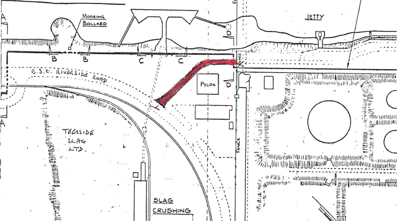
  79. D says that the 1925 Deed gave the TCC a right of way along the then route from A to B, and from B to C, on the plan below ("the 1925 Route"), it already having a right of way from the breakwater (where the words "Tod Point" appear on the plan) to C and on to Fisherman's Crossing pursuant to the 1891 Deed ("the 1891 Route").
  80. Image 004

    Fig 4
  81. When in 1974 the route was changed again, D says it acquired a right of way by implication over the diverted route in the 1974 Conveyance. The extent of the deviation between the 1925 Route (shown as the red pecked line) and Access Route 6 (shown as the solid red line) can be seen below. The deviation begins at point B on the 1925 route and so D still relies on the 1925 Deed for a right of way from B to C and on the 1891 Deed for a right of way between C and Fisherman's Crossing.
  82. Image 005

    Fig 5
  83. The STDC parties attack every stage of D's attempted compilation of a complete right of way over Access Route 6.
  84. The challenge to D's ownership of South Gare

  85. In their skeleton arguments for trial, the STDC parties for the first time raised a challenge to D's paper title to South Gare.
  86. By a conveyance dated 8.9.1863, it seems that the TCC acquired the land from the Crown on which it intended to build the breakwater. A copy of this conveyance has not been found, but it, together with a deed dated 31 July 1869 whereby the TCC acquired parts of what became the breakwater from the Newcomen Estate, was referred to in subsequent conveyancing documents as the root of the TCC's title to the breakwater. From 1863 onwards D and its predecessors have constructed, maintained, used and occupied the breakwater.
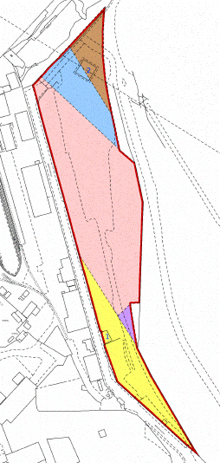
  87. However, the THPA only became the registered owner of South Gare (the land shaded light blue on Fig 3) as a result of a deed of exchange dated 8 May 1980 ("the Deed of Exchange"). By that deed, the Crown conveyed South Gare to the THPA in exchange for the THPA conveying back to the Crown the land it had acquired in 1863.  The conveyance plan below shows in pink the land the THPA acquired in 1980 (and D continues to own) and in blue the land that the TCC had acquired by the conveyance dated 8 September 1863 and owned until 1980. 
  88. The STDC parties say that any rights D claims under any instrument to which it was party prior to 1980 cannot have been proprietary rights benefiting the land which D currently owns.  Accordingly, D's claim under the 1974 Conveyance (either express or impliedly diverting the 1925 Route) must fail, as the allegedly burdened land did not give access onto D's then land (coloured blue below), but onto the pink land which was then Crown land.
  89. Image 006

    Fig 6

  90. D does not dispute that the Deed of Exchange suggests that either (1) the Crown conveyed some of the wrong land to the TCC in 1863 or (2) when building the breakwater, the TCC built it partly along the wrong alignment. D says that this is not a point that the STDC parties are entitled to raise on their pleadings, and in any event, this does not lead to the conclusion for which they contend.
  91. As to the entitlement to raise it, D says that, although the STDC parties had the 1980 Deed of Exchange, they raised no positive case about it in their pleadings, and merely put D to proof of the ownership of South Gare at the date of the 1925 and 1975 Conveyances. These pleas were introduced only by amendment in July 2023, with Teesworks explaining that the amendments "all go to the construction of the relevant documents" in relation to D's case on diversion of the 1925 route. There was no express denial of THPA's title to any relevant land, nor any positive plea based on the Deed of Exchange.
  92. D rightly says that the STDC parties cannot raise a positive case against D's title to South Gare at the relevant dates, but I do not think that D can ignore the 1980 Deed, and effectively treat the non-admission as an admission. It is right that the STDC parties had the information to plead a positive case, denying D's title rather than resting on a non-admission, but what D cannot say is that on the information it had, the STDC parties should have admitted D's title; see SPI North Ltd v Swiss Post International (UK) Ltd [2019] EWCA Civ 7 at [48]-[49]. While the STDC parties cannot raise a positive case on the 1980 Deed of Exchange, D must still prove a prima facie case of ownership of the Gare at the date of the conveyances on which it relies. D could do that if it could prove a prima facie paper title at the relevant dates from the conveyancing documents. Then no positive case could be advanced to displace that prima facie title. D's difficulty is that it cannot prove a prima facie paper title prior to 1980. D has to rely on the Deed of Exchange to show that D now has paper title to South Gare, but that also shows that it did not have paper title to it before the Deed of Exchange.
  93. D's response is that so far as the THPA's ownership of the pink land is concerned the 1980 Deed of Exchange was completely unnecessary. This is because, it says, the construction of the breakwater was a clear act of taking possession of the land on which it was built, thereby ousting the Crown's possession of that land. While the TCC and its successors had a statutory duty to build and maintain a breakwater and the facilities there, that gave it no right to enter upon the land of another to do so, so its activities on the land were qua owners. Under the common law, that possession immediately gave the TCC and its successors a prima facie estate in fee simple, good against all the world except for the true owner: see Jourdan, Adverse Possession at para 20-23 et seq. The TCC believed it was the owner of the breakwater and since then it and its successors have maintained the breakwater and acted in all respects as its owners, including in its dealings with the STDC predecessors who have treated it as the landowner. Pursuant to s.1 of the Crown Suits Act 1861 and s. 4 Limitation Act 1939, after 60 years the TCC's prima facie title will have become indefeasible by the Crown. This will have expired at the latest in 1948.
  94. I accept these submissions that the TCC had a prima facie possessory fee simple from at least 1888. There is no reason in principle why easements cannot be acquired or reserved for the benefit of a possessory fee simple. I also accept that the TCC's possessory title became prima facie inalienable from at least 1948.
  95. It will require a positive case to disprove that prima facie title to the land and as I have already indicated no such positive case was raised by the STDC parties. I declined to allow Miss Holland to raise a completely new point in her oral closing submissions, based upon s.66 of the Tees Conservancy Act 1875 (prohibiting interference by the TCC with Crown land without written consent). Firstly, this impermissibly raised a positive case and secondly raised a new point for the first time far too late in the proceedings. There might be arguments available to the Crown, if it chose to challenge the inalienability of the TCC's and THPA's title prior to 1980. Those arguments might be based on s.66, and indeed the express recital in the Deed of Exchange which state that the Crown was then the owner of the pink land. I am not convinced they are points which could have been taken by the STDC parties if they had chosen to raise a positive case, and they do not appear to affect the TCC's prima facie possessory fee simple.
  96. The 1891 Deed –Fisherman's Crossing to Point C

  97. The 1891 Deed conveyed a section of reclaimed land immediately adjoining the western side of the breakwater from the TCC to the Newcomen Estate. Among the various rights granted and reserved, the Newcomen Estate were granted access across the breakwater (and the railway running along it) to connect their land on either side, and they granted the TCC the following right of way:
  98. "the said Tees Conservancy Commissioners and their tenants, servants and workmen shall be entitled to have and use a free and convenient right of way between their cottages erected near Tod Point and the land adjacent thereto and the Village of East Coatham in such course or direction as the said [Newcomen Estate] Trustees or their assigns may from time to time assign for the purpose".
    The cottages are marked on the accompanying plan and appear on other contemporaneous plans and maps. East Coatham is also marked on contemporaneous maps, being further east along the road from Fisherman's Crossing.
  99. This granted the TCC a right of way to and from the breakwater over a route to be chosen by (at that time) the Newcomen Estate.
  100. The dominant land benefitted by the right of way is not expressly identified by the 1891 Deed. Where an easement is created by an express grant, there is no legal necessity for it to specify the dominant tenement, but it is essential that there is one. The court will consider the facts known to the grantor and the grantee at the time of the grant, to identify the dominant tenement and its extent. The breakwater at this point was in the ownership of the TCC and was its means of access to South Gare. This right of way appears to be the only road access to the breakwater and was for the TCC's tenants, servants and workmen. The purpose of obtaining access to this point of the breakwater must have been to thereby gain access to the rest of the breakwater and the land it accessed. I determine that the dominant tenement included South Gare and not just the part of the breakwater immediately adjacent to the cottages.
  101. D says that the plan to the 1925 Deed (Fig 4 above) shows that the chosen route (at least by 1925) was over Fisherman's Crossing, through an archway under the Jetty Railway at point C and then along the yellow track or road to the breakwater where the words "Tod Point" appear on the plan.
  102. The STDC parties dispute that point C (the archway) to Fisherman's Crossing was part of the chosen route pursuant to the 1891 Deed. They point to a map in 1893 showing the existence of other routes between the cottages and Fisherman's Crossing. Nevertheless, I am satisfied on the balance of probabilities that D is correct. D's contention is consistent with the 1913 OS mapping and the plans to the 1917 Agreement, the 1917 Deed and the 1925 Deed. It is clear from those documents and others, that the 1925 Route was an extension of the by then existing road from Fisherman's Crossing to the archway.
  103. The STDC parties also say that any right of way from Point C to Fisherman's Crossing is not a right of way for vehicular access. However, there is nothing in the 1891 Deed to restrict the use of the right of way, and unless there is something in the context or factual circumstances which indicates otherwise, it is a general right of way for all purposes for which the way was suitable; Kain v Norfolk [1949] Ch 163 at 168, Cannon v Villiers (1878) 8 Ch D 415 at 420-1. There is nothing in the context to indicate that a restriction to non-vehicular access was intended. At the time of the 1891 Deed, the STDC parties say, labourers employed by the TCC probably travelled on foot or by bicycle. Even if that be right, I have no reason to think that the route was only to be used by labourers and not also by supervisors, surveyors, engineers, and others who might be accustomed to travelling by horse, cart or carriage. The right of way extends to the village of East Coatham some distance away, and it would have been reasonable for those who were able, or enabled by the TCC, to use a horse or cart to travel to and fro and transport tools and material. There is also nothing in the evidence to indicate that a right of way for vehicles was not suitable. As discussed below, by 1917 there was a tarmac road which it seems may have been 20 foot wide (that being the width of the extension to it).
  104. The 1925 Deed – Points A to B and Points B to C.

  105. The route was changed in 1925, apparently to enable Dorman Long to redevelop and considerably expand Coatham Iron Works.
  106. By an agreement for sale and purchase between the TCC and Dorman Long, dated 14.8.1917 ("the 1917 Agreement"), so far as relevant to the right of way:
  107. 82.1. Dorman Long was to acquire the land which was to become the 1925 Route (A to C on Fig 4) from the Newcomen Estate. This was intended to be wide enough to construct a new road (at least 20 feet wide) and all necessary embankments. This new road was to be "from the Jetty Railway Archway to the Redcar Jetty approach ... in continuation of the present "Fisherman's Crossing" road from Coatham and to join up with the surface of the South Gare Breakwater". If Dorman Long could not acquire the land for the 1917 Road, they were instead to acquire a perpetual right of way for Dorman Long and the TCC.
    82.2. Dorman Long was to construct the new roadway along this route, with a tar macadamed surface, for the private use of the TCC and Dorman Long.
    82.3. Once completed, Dorman Long was obliged to grant, and the TCC obliged to accept, a perpetual right of way over the 1925 Route in substitution for the right of way granted by the 1891 Deed (between point C and the breakwater at Tod Point).
  108. By deed dated the same day ("the 1917 Deed"), Dorman Long acquired ownership of points A to B of the 1925 Route from the Newcomen Estate. As to the balance (points B-C), they were granted a right to extend the road "together with a perpetual right of way ... for [Dorman Long] at all times and for all purposes over the said extended road". This was neither the acquisition of the land, nor the procuration of a perpetual right of way for both Dorman Long and the TCC that the 1917 Agreement envisaged.
  109. The road was built and the 1925 Deed was made. By clause 1, the TCC were purportedly granted a right of way for all purposes between points A and C. From that point onwards, the access road to South Gare was the 1925 Route and the existing road joining to the public highway via Fisherman's Crossing. This remained the case until around 1974.
  110. The STDC parties dispute that the 1925 Deed was effective in giving the TCC a right of way from points B to C. They correctly observe that Dorman Long was not the owner of the land between B and C, instead only having a perpetual right of way over that land. Consequently, Dorman Long lacked the capacity to grant any right of way along that part of the route to the TCC.
  111. D seeks to get around this problem as follows:
  112. 86.1. The 1917 Deed granted a right of way between points B and C. That right was granted for the benefit of the land conveyed to Dorman Long under that deed, including the 1925 Route between points A and B. That was the dominant tenement.
    86.2. That dominant tenement was a route of access to other land, so the right of way could be used as a route of access to the land at and beyond point A on the 1925 Route: see Nickerson v Barraclough [1980] Ch 325, 336E-H; distinguishing Harris v Flower (1904) 74 L.J. Ch. 127 at 132 in such a situation (Harris v Flower is authority for the proposition that ordinarily a right of way to get to the dominant tenement may not be used so as to pass over the dominant tenement to get to other land).
    86.3. When Dorman Long granted the TCC a right of way over between points A and B, it thereby granted to the TCC a legal interest in the dominant tenement under the 1917 Deed. That carried with it the benefit of the right of way to that dominant tenement under the 1917 Deed, i.e. the right of way between points B and C under the 1917 Road. The fact that the TCC were granted an easement rather than, for example, a lease, does not make them any less entitled to exercise Dorman Long's right of way.
  113. Ms Barton submitted that, as a matter of construction of the 1917 Deed, it was only Dorman Long's land beyond point A which was intended to be benefitted by the perpetual easement over B-C. I do not agree. The land at A to B was the dominant land benefitted by the easement over B-C. The requirement that the dominant land is in the ownership of the grantee is therefore satisfied. That land was purchased to build a road to replace the existing road to the breakwater, and I do not see any justification for finding as a matter of construction an intention to restrict its use to only accessing some of the land accessed by the previous road beyond point A.
  114. Nevertheless, I do not accept D's analysis. Where I consider it falls down is in the proposition that, by granting the TCC a right of way over the road between A-B, the TCC thereby became a successor in title to a sufficient part of that land to carry with it the benefit of Dorman Long's easement over B-C. No authority has been produced to support this proposition. An incorporeal hereditament such as an easement is capable of itself being a dominant tenement for the grant of some right which is appurtenant to it; see Hanbury v Jenkins [1901] 2 Ch 401. That is not the issue here, as there is no valid grant of rights by Dorman Long to the TCC over B-C because Dorman Long did not own the land at B-C. The easement over B-C is notionally affixed to Dorman Long's land between A-B as the dominant land. It would pass on a transfer of title to the dominant land comprising A-B (or if the land is partitioned, any part of it; Newcomen v Coulsen (1877) 5 Ch D 133 at 141)) and it can be enjoyed by those occupying the land at A-B. An easement granted over A-B, however, is not a transfer of part of the title to A-B. Nor does it confer rights of occupation of A-B (as under a lease). It is simply the creation of a right to use the land. It does not make the TCC a successor in title of all or part of the land at A-B so that the benefit of the right of way over B-C passes to it.
  115. D's alternative argument is that if in some way the 1925 grant was ineffective, Dorman Long were estopped by deed from denying that right, which estoppel was 'fed' in 1954, when it became the owner of the road from B-C. Estoppel by deed is a common law doctrine, not an equitable one. Two categories of estoppel by deed were identified in First National Bank plc v Thomson [1996] Ch 231. D relies on the first category only:
  116. "where the grant contained an express recital or other clear and unequivocal representation of the grantor's title, he was estopped from denying that he had the particular title which he had asserted".
    As Millet LJ explained of this technical and limited estoppel, it is based on an express representation of a specific title:
    "It requires an express and unambiguous assertion or representation of title by the grantor, and usually takes the form of a recital in the grant".
    It is to be distinguished from the wider second category (on which D does not rely) which precludes a grantor from disputing the validity or effect of his own grant. On the issue of estoppel by deed, the passage in Taylors Fashions Ltd v Liverpool Trustees Co [1982] 1 QB 133 at 159B-F has to now be read in light of First National Bank v Thomson, as it seems to me to elide the two categories.
  117. As the STDC parties say, however, there was no "clear and unequivocal" statement in the 1925 Deed by Dorman Long that it owned B-C. The 1925 Deed was in fact scrupulously clear about the extent of Dorman Long's interest. The recitals to it recorded that Dorman Long now owned the land between points A and B in fee simple and had the benefit of a perpetual right of way between points B and C pursuant to the 1917 Deed. Although the deed goes on to express that Dorman Long "as Beneficial Owners hereby grant" the easement over the whole road A-C, that cannot be a clear and unequivocal representation of ownership in light of the explicit recitals. Therefore, insofar as the benefit of a perpetual right of way was insufficient to constitute Dorman Long as a competent grantor, it was not representing otherwise in the 1925 Deed.
  118. The 1974 Conveyance – a diverted route

  119. It is still necessary for me to consider the issues in relation to the 1974 Conveyance.
  120. The route of the access road was changed in around 1974 to facilitate the redevelopment of Redcar Iron and Steel Works by British Steel. The deviation is highly likely to have been agreed between the THPA and British Steel. But there is no evidence of any such agreement and an express right of way over the deviated route must be by deed; s.52(1) of the LPA 1925 provides that "all conveyances of land or of any interest therein are void for the purpose of conveying or creating a legal estate unless made by deed". D therefore seeks to rely on an implied right arising under the 1974 Conveyance to use the new route to get to and from Fisherman's Crossing. It seems to me that if D is correct in its submissions as to the effect of the 1974 Conveyance, it will also remedy the invalid grant in the 1925 Deed of a right of way over B-C. Indeed, it would not be necessary for D to rely on either the 1891 Deed or the 1925 Deed at all, as an implied grant in the 1974 Conveyance would give it a complete right of way over the STDC parties section of the road to South Gare.
  121. By the 1974 Conveyance, the THPA sold part of the breakwater to British Steel. This is the land marked dark blue on the plan below prepared by the experts from the conveyance plan ("the 1974 parcel").
  122. Image 007

    Fig 7
  123. Over the northern part of the 1974 Parcel, the THPA reserved to itself "the right for [the THPA] to pass and repass at all times with or without vehicles plant and equipment over and along the area [marked on the conveyancing plan] for all purposes until such time as the Corporation is able to grant to [the THPA] an alternative right of access acceptable to [the THPA]". This area ends where the new route (marked on the plan in light blue) meets the land being conveyed to British Steel, so seems to have been intended to provide for the continuation of the THPA's access to South Gare from Fisherman's Crossing along the new route which had by then been constructed.
  124. D says it would have been absurd for the THPA to reserve a right of access that could be used only to travel between South Gare and the end of the land over which the right was expressly reserved. D submits that a grant by British Steel in favour of the THPA over the rest of the route can be implied as a matter of the application of the rules of construction to the 1974 Conveyance. Those rules, as they are now understood, are that the interpretation of a contract is the ascertainment of the contract's meaning to a reasonable person with all the relevant background knowledge. A term which is not in the written contract can only be implied if the court finds that the parties must have intended to include that term in their agreement; it is not enough that it is a term that reasonable parties would have agreed to if it had been suggested to them. It must be a term which is necessary to give the contract business efficacy or be a term which is so obvious as to go without saying; Marks & Spencer Plc v BNP Paribas Securities Services Trust Co (Jersey) [2015] UKSC 72.
  125. In the context of easements, it may be said that these principles of construction find expression in the explanation of Lord Parker of Waddington in Pwllbach Colliery Co. Ltd v Woodman [1915] A.C. 634 {AU/81} at 646–7:
  126. "My Lords, the right claimed is in the nature of an easement, and apart from implied grants of ways of necessity, or of what are called continuous and apparent easements, the cases in which an easement can be granted by implication may be classified under two heads. The first is where the implication arises because the right in question is necessary for the enjoyment of some other right expressly granted. The principle is expressed in the legal maxim " Lex est cuicunque aliquis quid concedit concedere videtur et id sine quo res esse non potuit." Thus the right of drawing water from a spring necessarily involves the right of going to the spring for the purpose….
    The second class of cases in which easements may impliedly be created depends not upon the terms of the grant itself, but upon the circumstances under which the grant was made. The law will readily imply the grant or reservation of such easements as may be necessary to give effect to the common intention of the parties to a grant of real property, with reference to the manner or purposes in and for which the land granted or some land retained by the grantor is to be used … But it is essential for this purpose that the parties should intend that the subject of the grant or the land retained by the grantor should be used in some definite and particular manner. It is not enough that the subject of the grant or the land retained should be intended to be used in a manner which may or may not involve this definite and particular use."
  127. In Stafford v Lee (1992) 65 P. & C.R. 172, Nourse LJ explained in relation to the second class of cases at p.175:
  128. "There are therefore two hurdles which the grantee must surmount. He must establish a common intention as to some definite and particular user. Then he must show that the easements he claims are necessary to give effect to it."
  129. It seems to me that an application of the principles in Pwllbach, should not be allowed to detract the court from the primary exercise which it is undertaking, namely ascertaining the meaning of the document to a reasonable person, including the implication of terms a reasonable person would conclude that the parties must have intended to include in it. No doubt most circumstances which fall into one or other of the two heads referred to by Lord Parker will also satisfy the ordinary rules of construction. But it is possible that there will be cases where they do not. It seems to me that this is one such case.
  130. On the face of it, both heads of classification in Pwllbach are engaged. Firstly, the reserved right was a right of way over part of the road to access D's land at South Gare (the 1974 Conveyance refers to the reserved right continuing until "an alternative right of access" is made available). That right could only be used or enjoyed if there was a right to get to that section of road over the rest of the road from Fisherman's Crossing. Secondly, the relevant background includes the long-established use by the THPA of its land at South Gare to maintain the marine facilities there (including a breakwater, a lighthouse, a coastguard station, a pilot station, a radar and radio installation, a marina and fisherman's cabins). A reasonable person would infer that the THPA and British Steel intended that use to continue. Access to South Gare, and a right of way over that part of the route, which was owned by British Steel, was necessary for that use.
  131. However, the problem with D's submission seems to me to be that the 1974 Conveyance is a discrete and limited transaction – it deals with the conveyance of the 1974 parcel by the TCC and matters consequential upon it and nothing else. Save for an express reservation of a right of way over the new route on the part of the land sold on which it ran, there is no reference in it to the new route or to British Steel's land over which the new route ran. It is perfectly business efficacious, in achieving its apparent object of conveying the 1974 parcel and dealing with matters arising from that. There is no need to imply a term to give it business efficacy. It is impossible to say that it is obvious that the parties intended British Steel to grant a right of way over the rest of the route by this document. On the contrary, it seems to me to be quite clear from the document that there was no such intention. There is a deliberate and careful reservation over part of the route, which shows the draughtsman and the parties (who were sophisticated landowners) had the route well in mind but made no attempt to make provision in respect of the rest of the route. That appears to have been deliberate. It may be that it was intended that further documentation would be executed with a grant of such a right of way. It may be that there was a mistaken assumption, that the THPA already had a right over the remainder of the route. Neither are matters which can be corrected as a matter of construction, as opposed to, say, by an estoppel by convention (which is not pleaded or contended for).
  132. D has therefore failed to establish an implied grant of a right of way in the 1974 Conveyance.
  133. Conclusion

  134. D has failed in its attempts to compile a complete right of way across Access Route 6 from the three deeds.
  135. On one of the plans prepared by D's expert the 1974 parcel does not connect to the rest of D's land at South Gare. There is no suggestion of any gap on Cs' expert plans and nobody suggests that any gap was intended. I am satisfied that this is a drawing error by D's expert.
  136. H.2 Implied rights to access Redcar Quay

    Redcar Quay and Access Route 5

  137. Redcar Quay is the land marked blue on the plan below. The yellow and orange land belongs to the STDC parties. The only road access to Redcar Quay is marked in red and pecked red – Access Route 5. The white land between Redcar Quay and the STDC Parties' land coloured yellow, and which Access Route 5 crosses in pecked red, belongs to RBT.
  138. Image 008

    Fig 8
  139. From around 1969 there were plans to redevelop the Redcar site, replacing the original ironworks with a modern steelworks facility. Part of the redevelopment of the Redcar ironworks was the construction of a new ore quay and terminal. This required extensive excavation of the riverbed to permit access from ships with higher deadweight tonnage than had previously been possible, and the reclamation of the tidal flats on which the new Redcar steelworks would be constructed.
  140. Land was transferred by British Steel to the THPA to build the quay, with the intention that the THPA should lease it to British Steel to be used in conjunction with the facilities being constructed by British Steel at the site. A number of papers were prepared by the engineers, who built the quay or worked on the unloading and distribution system, from which it can be seen that the quay was intended to receive the importation of 7 million tons of foreign ore per annum and then distribute it by rail to ironmaking plants in Cleveland, Hartlepool, Consett and Workington. The unloading and distribution system used a conveying system to move the ore from the quay to the wagon loading station, where a purpose-built fleet of tippler railway wagons could be loaded with ore. What was eventually to become Access Route 5, featured in early drawings before work was commenced, but the road was not the intended distribution method for the ore. Access Route 5 was partially complete in 1974 and first appears in completed form on the historical mapping in 1980. Prior to Access Route 5's completion, there must have been other road access – there are references in the engineering reports to 1.1 million cubic metres of blast furnace slag being brought in by road to reclaim land for the quay.
  141. By a conveyance on 26.5.1971, British Steel conveyed the Redcar Quay to the THPA ("the 1971 Conveyance"). This reserved a right of access to British Steel in order to provide and install unloading equipment "for use in connection with the Quay about to be constructed by the Purchaser on the said land". In fact, it seems construction had already begun by the date of the 1971 Conveyance. At the time of the 1971 Conveyance, British Steel owned all of the land over which Access Route 5 now runs.
  142. Redcar Quay was then leased to British Steel by the 1974 Lease, which demised Redcar Quay for a term of 20 years from 17.06.1973. It reserved a right for the lessors to use the quay for other traffic. In 1995, the 1974 Lease was renewed for a term of 40 years from 17.06.1993 ("the 1995 Lease"). It included the same reservation permitting use of the quay by D:
  143. "The Lessors shall have the right to use the said Quay forming part of the demised premises for traffic other than that of the Lessees but subject in each instance to the prior written consent of the Lessees and only to such extent that this can be done without impeding the use of the Quay for traffic of the Lessees which shall in all respects have priority…"

    D's case – implied rights in the 1971 Conveyance and the 1995 Lease

  144. D does not claim to enjoy the benefit of any express rights of access to Redcar Quay, nor is any prescriptive claim pursued. Instead, D says an easement arises by way of implication into either the 1971 Conveyance or the 1995 Lease. D puts its case on rights of access to the Redcar Quay on three bases:
  145. 109.1. A right of way implied into the 1971 Conveyance by reason of its intended purpose;
    109.2. A right of way by necessity being implied into the 1971 Conveyance; or
    109.3. A stand-alone claim to an ancillary right of way in the 1995 Lease in order for D to be able to exercise its reserved rights under that lease.

    1971 Conveyance - rights to give effect to intended purpose

  146. I have set out earlier in this Judgment, the principles applied by a Court in the construction of a document and the implication of terms. I have also referred to the principles of construction, as expressed in the context of an implied grant of an easement in Pwllbach and Stafford v Lee.
  147. It is clear that the common intention of British Steel and the THPA at the time of the 1971 Conveyance, was that the new Redcar Quay would be built and operated as a quay. The 1971 Conveyance itself referred to "the Quay about to be constructed" and it is identified as a proposed quay on the plans to the 1971 Conveyance.
  148. D submits that a right of way between the land on which the Quay was to be built and the public highway was necessary, to give effect to that intended purpose. The quay could not have been built, nor could it be operated, without it. Operation as a quay means operation for the unloading and/or loading of goods or materials between ship and land, to enable their transportation onwards: landward access to and from the public highway is an essential part of this. Such landward access was also needed to bring the plant and materials required to build it; and it would have been known that it would continue to be needed for the people, plant and materials required to operate and maintain it.
  149. The STDC parties answer to this is that the Redcar Quay was intended to be leased to British Steel and operated by it – so the THPA did not need access. Secondly it was to be operated by British Steel as a quay servicing its ore storage and distribution facilities at Redcar. Road access was not required for the unloading and distribution of ore which was intended to be dealt with by the conveying system and railway.
  150. Discussion

  151. It is clear that the common intention of the vendor and the purchaser to the 1971 Conveyance was that the land would be used to build a quay which would be used as a quay in conjunction with the ore facilities. The construction of the quay is long since complete and any implied right of access for that purpose is now irrelevant. The question is whether D can prove that road access is necessary for its use as a quay in conjunction with the ore facilities.
  152. The fact that the operator of the quay might be British Steel, as lessee, who owned the adjoining land does not seem to me to be an answer. The question is not whether the THPA needed access to the quay when it was going to be let to British Steel, nor is it whether British Steel needed a right of way when it owned the adjoining land. The question is whether road access is necessary for the use of Redcar Quay as a quay.
  153. The answer to that question seems to me to also be clear - yes. The quay needs to be maintained. The plant and machinery on it need to be serviced, renewed and replaced. The quay needs to be staffed. For that reason alone, road access is and always has been necessary for its ordinary use as a quay. A reasonable person would conclude that the parties intended there should be road access for that purpose.
  154. In principle operation as a quay also requires road access to enable goods to be delivered for loading or distributed after unloading. In this case, the quay was intended to be used in a specific way in conjunction with the ore facilities. Road access was not generally required for the unloading and distribution of ore, which was intended to be dealt with by the conveying system and railway. There might still be a requirement for road access for its use in conjunction with the ore facilities – I can conceive that it might be necessary to use road distribution if the conveying system fails or there is a problem with the railway, or for distribution to a plant which was not serviced by the railway. There is no evidence of that before me.
  155. It might be said that, at some point in the future, Redcar Quay may not be used in conjunction with the ore facilities. It might be used for some other purpose for which road access is necessary to load and unload goods. I do not think that assists D. It is not enough for D to show that Redcar Quay might be used in this way in the future – it has to show that it was the common intention at the time of the 1971 Conveyance that it would be so used; see Pwllbach Colliery. Else it cannot show that the parties must have intended to grant or reserve a right for such future use.
  156. RBT

  157. RBT has not been joined to these proceedings. It has made clear that it has no desire to be included in this litigation. It currently does not take issue with D's use of Access Route 5 over its land to access Redcar Quay.
  158. The STDC parties say that the absence of RBT is fatal to D's claims in relation to Redcar Quay. They say RBT is a necessary party. Had the STDC parties raised the point timeously in these proceedings, RBT could have been joined and no doubt would have played a minimal role. I do not accept their protestations that it was for D to join RBT. CPR 1.3 requires the parties to litigation to help the court further the overriding objective of dealing with cases justly and at proportionate cost. This requires litigants to take reasonable steps to ensure that there is a common understanding as to the substantive and procedural issues in play; see Abbott v Econowall UK Ltd [2016] EWHC 660. That is not achieved by leaving an issue as to whether the proceedings have been constituted with the right parties until the run up to trial and the skeleton arguments for trial.
  159. Fortunately, the STDC parties are wrong in their assertion that RBT is a necessary party. It may have been a desirable party, to ensure that it was bound by my Judgment, but it is not a necessary party. No relief is sought against RBT in these proceedings. The only declarations sought are as to rights over the STDC parties' land; and such declarations will be binding on and affect only the STDC parties and their successors in title. RBT will not be bound by my findings in this Judgment. I can take care to fashion an appropriate declaration in respect of D's rights in relation to Redcar Quay so that they do not affect RBT.
  160. There is a risk that one day there will be another trial to vindicate a right of way over the land owned by RBT. There is a risk that at that trial, the judge will reach different conclusions to me on different evidence. That is undesirable, but I consider that there remain pressing reasons for continuing in the absence of RBT, in particular to resolve the current dispute which is as between the STDC parties and D.
  161. Conclusion

  162. I conclude that there is an implied grant of a right of way in the 1971 Conveyance, for the purpose of using Redcar Quay as a quay where the primary system of loading and unloading does not generally require road access.
  163. It is not necessary to consider D's fall-back arguments for an easement of necessity or a limited easement arising under the 1995 Lease and I do not do so. These arguments would only arise if I am wrong that road access is needed for the intended use of the land in 1971. At this stage, it is not clear to me what counterfactual I should use for analysis of the fall-back arguments.
  164. H.3 South Bank – express rights in Swan Hunter Conveyance

  165. On 3 December 1946 Swan Hunter conveyed to the TCC certain land beside the River Tees on the South Bank ("the Swan Hunter Conveyance"):
  166. "TOGETHER ALSO WITH for the purpose of gaining access to the said land hereinbefore described a right of way for the Purchasers and their successors in title and assigns and all persons authorised by them for all purposes on foot and with carts carriages motors and other vehicles over and along the existing road marked "A" and "B" on the said plan".
  167. The same route was previously the subject matter of a grant by virtue of a conveyance dated 4 February 1924 from Bolckow Vaughan to Swan Hunter. Bolckow Vaughan (owners of the servient land) reserved the right "at any time it becomes more convenient as necessary for them to do as to close divert or otherwise alter the road between points marked A and B hereinbefore referred to and provide other road access to the said piece of ground".
  168. At the time of the 1924 grant, the southernmost portion of the route ended at Grangetown Station, where it was connected to the public roadways via an underpass. By 1953, the underpass had ceased to exist. There is no conclusive evidence as to when the underpass ceased to exist and it seems to me that the Swan Hunter Conveyance itself is evidence that it continued to exist as at its date in 1946 and the right of way granted continued to have utility to the dominant land at the time of the grant. In other words, the Swan Hunter Conveyance created a valid and binding easement over the identified route.
  169. However, it is fair to say that route has ceased to be of any utility long ago. The road itself has now disappeared (although D points out that Bolckow Vaughan and its successors were entitled to move the route). D says it is nevertheless entitled to a declaration of its continuing right under the Swan Hunter Conveyance.
  170. The STDC parties raised a number of points in their pleadings, including laches, which were not pursued in closing submissions. They were refused permission to amend to plead abandonment and extinguishment. They say that D has stood back and allowed the STDC predecessors to act on the burdened land, without making any assertion of these rights until its counterclaim in these proceedings. In that context, they submit that the Court should decline to grant declaratory relief – the granting of declaratory relief being discretionary; Rolls Royce plc v Unite the Union [2009] EWCA Civ 387.
  171. In circumstances where D has established a subsisting right which the STDC parties are unwilling to recognise (and indeed seek a declaration that it does not exist), it would require some exceptional reason for that right not to be vindicated by the grant of declaratory relief. I do not regard the alleged delay, in circumstances which do not affect the validity of the subsisting right or fall within one of the established doctrines for preventing the assertion of the right (such as laches or estoppel), to be sufficient grounds in this case for refusing relief.
  172. H.4 South Bank - express rights under the 1964 Deed

  173. On 26 December 1964, by a Deed of Exchange ("the 1964 Deed") the TCC acquired a rhombus of land south of the oil jetty and oil tanks, together with a right to construct an entrance to Access Route 1.  In the First Schedule, by paragraph 7, it defined the land to be conveyed by reference to a plan ("the Rhombus"). By the following paragraph at 8 it also granted an express right of way as follows:
  174. "to pass and repass over and along the lands of Dormans respectively coloured green and hatched green on the said Plan Numbered 1 and also (as to the said land hatched green) on the plan hereto annexed marked Plan Numbered 2 so as to enable the Commissioners and the tenants for the time being of the said land and all persons authorised by the respectively with or without vehicles plant and materials for the purposes for the time being permissible in accordance with Clause 15 hereof to obtain access and egress to and from the said land".
  175. The rhombus is hatched in dark blue on the plan below and the express right of way is marked in red.
  176. Image 009

    Fig 9
  177. Cs accept that D, as owner of the Rhombus, enjoys this express right. Teesworks does not dispute that D has this express right, but objects to the way the claim is pleaded and says it should be dismissed.
  178. Teesworks objects to the fact that paragraph 37(1) of the Re-Re-Re-Amended Defence to Counterclaim ("the RRRADCC") asserts that, "Teesport has the benefit of the rights granted by" the 1964 Deed and Teesport is defined elsewhere in the RRRADCC as all of D's land at Teesport. Mr Walker has conceded that he only contends that the Rhombus benefits from this easement. Ms Holland maintains that D is not entitled to the relief as sought. The relief sought in D's RRRADCC is "A declaration that D has a right to use the Defendant's 1964 Right of Way as defined in paragraph 37 of the Defence". Absent amendment to paragraph 37, she says, D cannot make out its case and it must be dismissed.
  179. In fact it is paragraph 37(2) that defined "the Defendant's 1964 Right of Way". It defined it as the right of way in paragraph 8(a) of the First Schedule to the 1964 Deed and quoted the excerpt set out above at paragraph 130. It is silent as to which land benefits from the easement. I see nothing that Teesworks can say requires amendment in that definition of "the Defendant's 1964 Right of Way" and therefore nothing which requires amendment in relation to the relief as sought in the prayer. I can address any legitimate concern Teesworks might have as to the land benefitted in the form of the order.
  180. I accept Mr Walker's concession of a lesser case as to the land benefitted without requiring further amendment to the pleading. It would be disproportionate to do otherwise.
  181. H.5 South Bank - implied rights under the 1964 Deed

  182. D also claims a right of way along that part of Access Route 1 between the 1964 Parcel and Smith's Dock Road. The claim is that such a right was implied into the 1964 Deed by s.62 of the Law of Property Act 1925.
  183. S.62 contains general words which, in the absence of a contrary intention, are implied into a conveyance. In particular s.62 passes to the transferee all rights and advantages which at the time of the conveyance appertain or are reputed to appertain to the land or are enjoyed with the land conveyed or part thereof. The effect of s.62 may be to create new easements by way of express grant where there were previously only quasi-easements. There is no requirement for the right or advantage to be necessary for the reasonable enjoyment of the land.
  184. The section envisages something which exists and is seen to be enjoyed as a right or advantage; Nickerson v Barraclough [1981] Ch 426. There needs to be a pattern of regular use. Where there has been no use at all within a reasonable period preceding the date of the conveyance s.62 cannot operate to create an easement; Wood v Waddington [2015] EWCA Civ 538 at [52].
  185. Access Route 1 was complete and in use by the time of the 1964 Deed. At that time, Access Route 1 was wholly owned by Dorman Long. D says that in addition to the express right of way under the 1964 Deed, from the Rhombus to the Tees Dock Road, it has an implied right pursuant to section 62 in the other direction, to reach Smith's Dock Road.
  186. Prior to the 1964 Deed, the Rhombus had been leased by Dorman Long to ICI and Shell – so there was diversity of ownership. It is not therefore necessary to show that the right or advantage was continuous and apparent in the sense used in the rule in Wheeldon v Burroughs (although a made up road has been described as the "easiest case" of a continuous and apparent right; see Hansford v Jago [1921] 1 Ch 322 at 338).
  187. The STDC parties suggested that there was no access point from Access Route 1 to the 1964 Parcel before the 1964 Deed. The language of the 1964 Deed, suggests that some sort of construction work was to be carried out at the intended access point from the Rhombus to Access Route 1. However, a Layout plan of Teesport in 1958 shows an entrance to the Rhombus was already there and the plans to licences granted by Dorman Long to ICI in 1962 and July 1964 also show it and describe it as the "main ICI access".
  188. D's difficulty, however, is that there is no evidence at all of use by Shell and ICI of Access Route 1 to get to the Smith's Dock Road prior to December 1964. Mr Walker says that there is no evidence that Dorman Long had a right of way over the Tees Dock Road and could only have provided to its lessees with access along Access Route 1 to Smith's Dock Road. Whatever rights Dorman Long had (or indeed Shell and ICI might have independently had), it is clear from the licences referred to above that the intended route of access and egress to the Rhombus was via the Tees Dock Road and not in the other direction.
  189. As I explain below when considering the claim for prescription, Access Route 1 was at this time a convenient route to travel to and from Teesport and was open to all. Employees or visitors of Shell and ICI could have used Access Route 1 from the Smith's Dock Road, but I have no evidence that they did. They could also have only used Access Route 1 from the Tees Dock Road because that was the route authorised by Dorman Long. I have very limited evidence as to how the Shell and ICI sites operated and the nature of the traffic to and from their sites; the 1962 licence suggests access to the ICI site was only required (and only authorised) for emergencies, construction and maintenance.
  190. D has not discharged the burden of proving its claim under s.62.
  191. PRESCRIPTION
  192. I.1 The relevant law

  193. Prescription describes the common law concept of a legal right over land that is acquired by use or enjoyment for the period and in the manner fixed by law. The right acquired is measured by the extent of the enjoyment that is proved; Williams v James (1867) LR 2 CP 577, 580.
  194. The manner of the use required is use "as of right" (in the sense of "as if of right"; per Lord Walker in R(on the application of Beresford) v Sunderland City Council [2000] 1 AC 335 at [72]).
  195. That has the same meaning as the Latin expression 'nec vi, nec clam, nec precario' – without force, without secrecy, without permission. Lord Rodger said of the Latin tripartite test in R. (Lewis) v Redcar and Cleveland Borough Council (No.2) [2010] 2 AC 70 at [87], "their sense is perhaps best captured by putting the point more positively: the user must be peaceable, open and not based on any licence from the owner of the land." In R v Oxfordshire County Council, Ex p Sunningwell Parish Council [2000] 1 AC 335 Lord Hoffman explained: "The unifying element in these three vitiating circumstances was that each constituted a reason why it would not have been reasonable to expect the owner to resist the exercise of the right - in the first case, because rights should not be acquired by the use of force, in the second, because the owner would not have known of the user and in the third, because he had consented to the user, but for a limited period."
  196. It has been decided at the highest level that "as of right" and the tripartite test (nec vi, nec clam, nec precario) are synonymous in meaning and effect; R(on the application of Beresford) v Sunderland City Council [2000] 1 AC 335 at [6] and [55], R (on the application of Lewis) v Redcar & Cleveland BC (No.2) [2010] UKSC 11 at [20] and [87], Lynn Shellfish Ltd v Loose [2016] UKSC 14, at [37]. Use which satisfies the tripartite test establishes a prescriptive right. There is no further criterion to be satisfied; London Tara Hotel v Kensington Close Hotel Ltd [2011] EWCA Civ 1356; [2012] 1 P&CR 13 (CA) at [28], [74].
  197. Use

  198. The use must accommodate the dominant tenement in the sense of being connected with the normal enjoyment of the dominant tenement.
  199. "The essence of an easement is to give the dominant tenement a benefit or utility as such. Thus, an easement properly so called will improve the general utility of the dominant tenement. It may benefit the trade carried on upon the dominant tenement or the utility of living there."
    Regency Villas Title Ltd v Diamond Resorts (Europe) Ltd [2018] UKSC 57 at [38].
  200. The focus is on the way the land has been used by the users and the quality of that use; Redcar per Lord Brown at [100]. The use in question must have the quality that the users have used it as one would expect those who had the right to do so, to have used it; Redcar per Lord Kerr at [116]. It must be of such amount and in such manner as would reasonably be regarded as the assertion of a right; Redcar per Lord Hope at [67]. It is judged by how the use would have appeared to the reasonable owner of the land; Redcar per Lord Walker at [30] and [36], London Tara per Neuberger LJ at para [29].
  201. It does not matter what the owner of the land and the users of the roadway actually think as to who the user is or why or on what basis the use is occurring. The subjective understanding and intention of the person or persons when enjoying the amenity now claimed to have been acquired by prescription is irrelevant; Sunningwell, per Lord Hoffman at 356A-D. The subjective understanding and intention of the owner of the land is equally irrelevant; London Tara per Lewison LJ at [60].
  202. The use must be continuous and uninterrupted.
  203. Peaceable use (nec vi)

  204. The authorities have held that peaceable use is use which is not just without force, but also use which is not contentious, because, for example, the servient owner objects and protests to the use. I do not need to consider this in any detail because it is not pleaded (and although raised in written closing submissions, was by the end of closing submissions no longer contended) by the STDC parties that any of the use relied on by D was contentious.
  205. Open use (nec clam)

  206. The use in question must not have taken place in secret; Redcar per Lord Kerr at [116].
  207. It is not contended that the use in question in this case took place in secret. If the landowner does not have actual or constructive knowledge of the use, then there may be an issue as to whether the use has been secret, for the purposes of the tripartite test. It is not contended here that the STDC predecessors did not have actual knowledge of the alleged use.
  208. Without permission (nec precario)

  209. Use will not be 'nec precario' if there has been some grant of permission by the servient owner, whether express or implied: see Beresford. As to the types of act which may be demonstrative of permission:
  210. 158.1. The classic example would be an express permission, such as the granting of a licence.
    158.2. Even where there is no express licence, an implied licence may arise. Lord Bingham said at [5]:
    "I can see no objection in principle to the implication of a licence where the facts warrant such an implication. To deny this possibility would, I think, be unduly old-fashioned, formalistic and restrictive. A landowner may so conduct himself as to make clear, even in the absence of any express statement, notice or record, that the inhabitants' use of the land is pursuant to his permission. This may be done, for example, by excluding the inhabitants when the landowner wishes to use the land for his own purposes, or by excluding the inhabitants on occasional days: the landowner in this way asserts his right to exclude, and so makes plain that the inhabitants' use on other occasions occurs because he does not choose on those occasions to exercise his right to exclude and so permits such use."
    158.3. Permission may also be demonstrated by the erection of an appropriately worded sign, as per Lord Rodger at [59]: "Prudent landowners will often indicate expressly, by a notice in appropriate terms or in some other way, when they are licensing or permitting the public to use their land during their pleasure only."
    158.4. Non-verbal acts may indicate the user is with permission, as Lord Walker explained at [75]:
    "…permission to enter land may be given by a nod or a wave, or by leaving open a gate or even a front door. All these acts could be described as amounting to implied consent, though I would prefer (at the risk of pedantry) to describe them as the expression of consent by non-verbal means. In each instance there is a communication by some overt act which is intended to be understood, and is understood, as permission to do something which would otherwise be an act of trespass."
    158.5. Permission cannot however be implied from mere inaction by the landowner: Lord Bingham at [6]. However informal, the arrangement must involve a positive act of granting the use of the property, as opposed to mere acquiescence in its use: Lord Rodger at [57].

    Length of use

  211. The law on prescriptive periods has been described as:
  212. "a mixture of inconsistent and archaic legal fictions, practical if sometimes haphazard judge-made rules, and (in the case of easements …) well meaning but ineptly drafted statutory provisions."
    Lynn Shellfish Ltd v Loose [2016] UKSC 14, per Lords Neuberger and Carnworth at [38]
  213. There are three periods of prescription recognised in English law which operate as follows:
  214. 160.1. In order to prescribe at common law, it is necessary to show that the user has been ongoing since 'time immemorial' which, since the First Statute of Westminster in 1275, has been fixed at the accession of Richard I in 1189. There is now a rebuttable presumption, that if the user has been ongoing for longer than living memory it can be traced back to 1189. This period is of no relevance in the present case since the relevant land was underwater until the mid-19th century, and so cannot have been burdened by any routes in the 12th century.
    160.2. Because of the obvious difficulties created by the common law, over time the courts created the fiction of 'lost modern grant' by which, if it could be shown that the user in question had been continuously ongoing for any period of 20 years, it could be presumed that the right had been expressly granted by a deed which could not be produced in court had since been lost. The fiction has now become a fixed rule of law such that even conclusive evidence that there was never any grant made will not prevent it from operating: Tehidy Minerals Ltd v Norman (1971) 2 QB 528.
    160.3. Finally, a third alternative was created by s.2 of the Prescription Act 1832. This also requires the user to have been ongoing for a period of 20 years (with interruption of up to one year being disregarded). But, in contrast to lost modern grant, by virtue of s.4 that period must be the period immediately preceding the commencement of the action.
  215. In this case, D relies on the doctrine of "lost modern grant" in respect of all its claim to prescriptive rights. In short, D must show 20 years of continuous and uninterrupted use. D also relies on s.2 of the 1832 Act in relation to South Gare, but it adds little to its claim.
  216. I observe at this stage that had there been merit in the STDC's parties' contentions on THPA's statutory capacity I would have had to consider the STDC's parties' submissions that this defeated D's prescription claims. There being a legal fiction that a grant was made pursuant to which the use followed, I would have found that a prescriptive right could still arise, notwithstanding any lack of capacity on the part of THPA to acquire new easements, particularly as use had commenced when the dominant land was owned by the TCC which did have the capacity to receive a grant.
  217. Burden of proof

  218. The dominant landowner (D) has the legal burden of proof of prescriptive use, but if it proves open use then an evidential presumption arises that the enjoyment was as of right - in particular, that it was without permission and not contentious. The evidential burden then passes to the servient landowner (the STDC parties) to prove permission and contention. The STDC parties have pleaded that Ds use was with the permission of one or more of the STDC predecessors. There is no plea of contention.
  219. I.2 Prescription – Access Route 6 to South Gare

    Use and period of use

  220. Access Route 6, which gives access to South Gare, became fixed on its current route in 1974, but before then there had been a single road giving access for many decades.
  221. The South Gare breakwater was constructed by D's predecessor and since 1893 has had a lighthouse and a coastguard station at its furthest reaches. A lifeboat station followed in about 1911. A pilot station came soon after. By 1970, there was a radar and radio installation.
  222. There is no dispute that D and its predecessors have maintained the breakwater, the lighthouse and many of the other facilities since they were put in place. There are written records like the Tees and Hartlepool Port Authority North and South Gares Breakwater study in 1987, which record the history of the breakwater's construction using 135 million tons of slag. As well as the regular need for remedial and maintenance work to prevent the breakwater breaking up.
  223. Since 1974, the only land access D has had for maintaining the facilities at South Gare has been Access Route 6. The shoring up of the breakwater sometimes requires depositing tonnes of material along it. For example, a recent piece of maintenance required the installation of 100 12-14 tonne armour blocks, requiring a hundred visits by concrete trucks. From 1974 they would have used Access Route 6 to do so.
  224. In addition, the facilities at the breakwater have had to be maintained. Mr Dalus was D's former General Manager of Engineering, having joined in 2012. He explained that currently there are cyclical checks carried out at South Gare at least weekly and there are records of those checks having been carried out over many years. Maintenance workers will have gained access to the breakwater from 1974, over Access Route 6.
  225. The facilities at South Gare have been manned and operated by D's employees and others, whose only land access for that purpose since 1974 has been Access Route 6. For example, the pilots who were based on South Gare (by licence from D and its predecessors) until around 2011 when the Government Jetty was washed away. There were multiple pilots on shift all day, every day. They will have used Access Route 6 to get to the pilot station.
  226. In addition to this, there are facilities on South Gare which are leased or licensed to the public. The South Gare Marine Club uses a building there. I heard from Alan Daniels who is the current Chairman of the Club which has 155 members. He has been a member for over 20 years. He explained that there is no written lease, but they pay an annual rent. There are about 130 boats in the marina there. There are cabins which are licensed to members of the public by D. There has been a diving club based there. Since 1974 all these facilities have been accessed by Access Route 6.
  227. D called over 20 witnesses to give evidence of their use of Access Route 6 to access South Gare. They were a selection of D's employees, agents, licensees and tenants who had a legitimate reason to go to South Gare. Their evidence of use of the road to South Gare covered the period from 1949 to date and the regularity of use ranged from daily to sporadic. The gist of the evidence of each is that they have used the single road to access South Gare, they believed they were entitled to do so, and save for the road closures which I will come to, they were not challenged or stopped or otherwise impeded. No one asked for permission to use the road. The nature of South Gare and its single route of land access means it is reasonable to infer that almost every other employee, agent, tenant or licensee of D and its predecessors, who had a right to be on South Gare has travelled to South Gare along Access Route 6 in a similar fashion. This includes all those making land deliveries of heavy materials and equipment. There will only be a small handful, like those operating survey boats not based at South Gare, who will have arrived and left by sea.
  228. I am satisfied that there has been open use of Access Route 6, as a means of access to the lighthouse and breakwater at South Gare and the facilities there for all purposes from the completion of the diverted route in 1974 to the date of trial. The evidential burden is therefore, on the STDC parties to show that such use was with permission of the STDC predecessors or was interrupted by a period of permissive use.
  229. This may be a convenient point to say that the witnesses were repeatedly cross-examined, as to whether they assumed or believed they were authorised or had permission to use the road. As I pointed out during cross-examination, it seemed to me that the witnesses understood that they were being asked whether they felt entitled to use the road. Most answered in the affirmative. Not only is their subjective belief irrelevant, but any affirmative answers to such questions do not provide evidence, that they were actually granted permission.
  230. Road closures

  231. For as long as anyone can remember there has been an annual closure of the road to South Gare. This has been done by Cs and D and their respective predecessors together. In recent times, the South Gare road has been closed by both D (and its predecessors) and Cs (and their predecessors), at the points where their respective parts of the road begin, travelling towards South Gare. The harbour police travelled between the two points to assist. The road closures were notified to the general public, in advance through the local press.
  232. There was a considerable amount of cross examination about these road closures. A number of clear points emerged:
  233. 175.1. The road closures were a joint and collaborative exercise between C and D (and their predecessors).
    175.2. All cars were stopped on the day of the road closure. Those with a legitimate reason for going to South Gare (such as pilots, lifeboat crew, and others attending for work, but also members of the public who were cabin tenants, or had a boat in the marina, or were a member of the Marine Club) were allowed to pass. Other members of the public were turned away.
    175.3. Nothing was said to those who were allowed through that their access was discretionary or by permission or could be refused.
    175.4. From about 2019 vehicle logs were completed by the security carrying out the road closure to record brief details of which cars were allowed through and which were not.
  234. The STDC parties rely upon the road closures as evidencing the grant of permission for use of the land to those who were allowed through. These road closures were clearly intended by Cs and D (and their predecessors) as an exercise of control by preventing access on one day of the year to members of the public, thereby displaying that the public's use for the rest of the year was with the permission of the landowners. It has little bearing on those who were not turned away. In particular, there is no evidence of a positive grant of permission to those who had a legitimate reason to travel to South Gare – they were allowed to pass as if they had the right to do so.
  235. Signage

  236. There is photographic evidence of signs stating that the road is private property having been in place at Fisherman's Crossing, where the public road ends and Cs' private road begins, in 2007. There is also evidence of private property signs having been present on other parts of Cs' road in 2009.
  237. The signs shown in the photographs read as follows:
  238. 178.1. "Corus UK Ltd Private Property [;] This is a private estate owned by Corus UK Limited [;] Court action may be taken against trespassers [;] All persons using the estate do so subject to the current Corus Site Regulations (…) All persons entering the estate must take care of their own safety and for the safety of their property (…) Copies of the Corus Site Regulations may be obtained from [address]";
    178.2. "Private Property [;] Motor cyclists are prohibited & offenders may be prosecuted";
    178.3. "Private Road [;] No unauthorised vehicles beyond this point".
  239. As to the witness evidence, some witnesses remembered seeing signs, a number of witnesses recalled signs having been present prior to the photographs in 2007, most said they paid no attention to them. Those who were travelling to South Gare for work or because they had a cabin or boat in the marina did not regard the signs as applying to them.
  240. In the context of an assertion that prescriptive user is contentious, then prominent signs prohibiting use of the land may be sufficient to make any use contrary to the signs contentious; see Winterburn v Bennett [2017] 1 WLR 646 (CA). These signs do not stipulate who Corus regards as "trespassers" or what were "unauthorised vehicles". These and other issues were not explored in submissions because there is no plea that D's and its predecessors' use of the land was contentious.
  241. The STDC parties rely on the signs as the grant of permission to all who used the road. A permissive sign (e.g. "This wood is private property but its use by dogwalkers is with the permission and at the discretion of the landowner") is capable of granting permission for the use of land. Ms Holland's argument is that the signs in this case are partly prohibitive and partly permissive. They prohibited unauthorised persons from using the road and thereby implicitly gave permission to authorised persons to use the road. I do not accept that the signs are capable of bearing that interpretation. These are completely prohibitive signs. They tell the world that unless they already have a legal right to be on the road, they are prohibited from using it. They do not purport to confer permission on anyone. Authorised users did not require permission. Those travelling to use the marine facilities at South Gare for work or because they had a cabin or boat in the marina did not regard the signs as addressed to them.
  242. Conclusion – Access Route 6

  243. D has therefore established that it has a prescriptive right for all purposes and all vehicles under the 1832 Act and the common law doctrine of lost modern grant.
  244. I.3 Prescription – general use of Access Route 1 across South Bank

    South Bank and Access Route 1

  245. The TCC acquired land at Teesport shaded blue in the middle of the plan below ("Teesport") between 1946 and 1955, save for the Rhombus which was acquired in 1964.
  246. Image 010

    Fig 10
  247. The principal access to Teesport is by an inland route via Lackenby and the Tees Dock Road. Access Route 1 connects D's land by the highway at Smith's Dock Road (the Smith's Dock Road parcel – light blue on the plan above) to Tees Dock Road on the Defendant's land at Teesport.
  248. By 1953, the Tees Dock Road had been constructed and is visible on OS mapping and aerial photographs, but the riverside road did not yet connect with it to form Access Route 1.
  249. The experts agree that the completed Access Route 1 is visible on the 1965 OS map but is not visible on the previous 1952-1955 edition. There are two Dorman Long plans dating back to 1955 (one revised in 1956 and the other in 1959) and a third plan in 1958, all of which show the riverside road had joined up with the Tees Dock Road to form Access Route 1 by those dates. These were not seen or commented on by the experts. Cs sought to raise doubts about the reliability of those plans as evidence that Access Route 1 was in existence by 1955 on the basis that the plans might be construction plans for a proposed completion of Access Route 1. Not only is there nothing in the documents warranting that speculation, but it would also be contrary to the descriptions of two of the plans as scale layout plans and could not explain why Access Route 1 appears on a plan for the laying of an unrelated feed cable. I find that Access Route 1 was complete by 1955.
  250. The deep-water port at Teesport was constructed in the early 1960s and officially opened on 4 October 1963, although there were already oil jetties (the Queen Elizabeth II jetty and the West Byng jetty) at Teesport. Access Route 1 can only have been used in connection with the operation of the deep-water port after 1963.
  251. By 1999 at the latest, Access Route 1 was blocked by the placing of an earth bund across the road to prevent vehicular access. The experts agree that the bund was in place in 1999 and in 2007 although there is plenty of evidence that it was a removable structure and it was removed by bulldozers if access was required. While the bund was in place the only access to and from Teesport was via the Tees Dock Road from the A66. The Tees Dock Road is susceptible to flooding at a particular point. The evidence as to the frequency of flooding varied, but it is clear that there are one or more incidents of flooding every year. When flooded the road is impassable to traffic. In 2002 D sought, and was granted, permission from Cs' predecessor Corus, to remove the bund and to use Access Route 1 for emergency access to Smith's Dock Road. D's claim for prescription does not rely on any use after 2002.
  252. Witnesses

  253. D called a number of witnesses to give evidence about the use of Access Route 1.
  254. Cs called a number of witnesses to give evidence of control by the STDC predecessors of the site. The evidence focussed on four features along Access Route 1, namely a weighbridge, the PCM Cabin, the placing of steel bars or an earth bund to block SDR and the East Wharf gateway. In addition, there was evidence as to security measures generally.
  255. Use and period of use

  256. I heard evidence from D's witnesses that Access Route 1 was regarded as the quickest route between Teesport and Middlesbrough before the A66 was built. Mr Norton said it was a regular run for those who knew the route in the 1970's and 1980's. The A66 was completed as far as Teesport at the end of 1990 or early 1991.
  257. From its completion until the opening of the A66, I am satisfied that Access Route 1 was used routinely and regularly as a route to get between Teesport and Middlesbrough.
  258. I heard evidence from the 91 year old Brian Bainbridge who worked for the TCC, THPA and D between 1949 and 1993. He was seconded to Randell, Palmer & Triton between 1949-1952 for the construction of the Tees Dock Road. He cycled to Teesport along Access Route 1 from offices in Middlesbrough for snagging works on the Tees Dock Road or for other development work.
  259. Patrick Taylor was employed by the TCC, the THPA and D from 1963 to 1995. When working in the wages department he was based in Teesport and he drove a weekly run along Access Route 1 and back to collect cash for the wages department between 1963 and 1967 and occasionally thereafter into the 1980's.
  260. Peter McWilliams was employed at Middlesbrough Dock from 1956. He was largely based at Middlesbrough Dock (which became part of THPA in 1967) until its closure in 1980. He travelled from Middlesbrough to Teesport by Access Route 1 to attend a weekly meeting between 1967 and 1980 to discuss which ships were to dock in Teesport and which to dock in Middlesbrough. He explained that it was the shortest route and he therefore believed it was the route which should be taken as a travel allowance was being claimed from the THPA.
  261. Keith Overfield was employed with the TCC from 1963-1964, and then the THPA from 1968-1995. He initially joined the TCC as a diver, and then returned as a captain of a boat in the conservancy team. From 1968, people in the conservancy team would use the van to travel Access Route 1. This was either to conduct surveys, with the van following the vessel along the road, or for a land survey being conducted at fixed points. The road was also used by his team to travel to Teesport to deliver survey results or if there was other business at the port. Roughly once a month he travelled Access Route 1 when dropping off a craft at the depot.
  262. Michael Westmoreland, another employee at the THPA, used Access Route 1 to get to and from Teesport for the purposes of his job from 1974 until at least the mid 1980's.
  263. Bernard Meynell was employed by the THPA and D from 1975 to 2009 based in Middlesbrough. He used Access Route 1 three or four times a week to get to meetings at Teesport until it was blocked.
  264. Paul McGrath was employed with the THPA and D between 1978 and 2018 (although he moved jobs to the Humber in 2006). He started as a general clerk at Middlesbrough and transferred to Teesport in 1979. He became the wages clerk in 1981. He was based at Teesport until 2006. He travelled regularly by bicycle or car to Teesport from Middlesbrough along Access Route 1, all year round from 1978 until it was blocked.
  265. Brian Dresser, another THPA employee used Access Route 1 to get between Teesport and the Smith's Dock Road (as well as to access jetties along the route) from 1981 into the 1990s.
  266. David Varey was an internal auditor for the THPA between 1983 and 1984 which required him to visit Teesport. The quickest route was Access Route 1 which Mr Varey used roughly on a monthly basis.
  267. Allan Duncan was employed by the THPA and D between 1989 and 1997 as Tees Dock Manager based at Teesport. As part of his job, he needed to drive to head office in Middlesbrough. He used Access Route 1 once or twice a week for the whole period of his employment for this purpose.
  268. Several of the witnesses gave evidence of being told about the route by colleagues at work and of knowing of other colleagues also using the route. I am satisfied that the evidence which I have heard is representative of widespread use of Access Route 1 to get from Middlesbrough to Teesport and vice versa. By the 1980's Access Route 1 was marked on a THPA map. Although not identified as a principal road, it is evidence that it was regarded by the THPA as a route for use in connection with the activities of the THPA. In a letter from a security manager at D to Corus dated 11.12.2002, Access Route 1 was described as having once been "one of the main access roads to the Teesport estate". I am satisfied that was an accurate description of Access Route 1 prior to the opening of the A66.
  269. After the A66 was built use of Access Route 1 dropped off. The A66 became the preferred route for most. Nevertheless, it is clear that Access Route 1 continued to be used, very regularly by some (for example Mr Maynell, Mr McGrath and Mr Duncan), until it was blocked by an earth bund.
  270. Apart from using Access Route 1 to get from Smith's Dock Road to Teesport, it was also used regularly to access points along the route, such as the wharves and jetties along the riverside. It was used by THPA employees to do hydrographic and land surveys along the riverside and for access for dredging and maintenance work. Until the arrival of a security portacabin at East Wharf Gate, at some point after 1987 (discussed below), Access Route 1 was accessible to members of the public and freely used to access points along the riverside. Mr Tabner travelled it regularly between 1968 and 1978 to collect driftwood for his house and travelled it almost daily in 1986 when writing a book about Smith's Dock. Mr Johnston and others travelled down it to park up and watch the boats come in at lunchtime or in the evenings. It was described as "open access" by Mr Tabner. I accept that as an accurate description of the position until at least 1987.
  271. Steel beams and earth bund

  272. At some stage beams and an earth bund were placed at the Smith's Dock Road end of Access Route 1 blocking it off. The purpose was to deter theft and other wrongdoing. The likely sequence of events is that steel beams were used as temporary barriers initially, and that practice was replaced by using a more substantial earth bund later. Mr Agar, who was involved in the first placement of beams suggests this happened in the 1990s. There is inconclusive aerial photography from 1995 which may or may not show a steel beam across Access Route 1.
  273. By 1999, an aerial photograph shows a blockage consistent with an earth bund across the road. In 2007, another aerial photograph shows a different earth bund in a similar position. The evidence was that that the bunds could be removed when access was required and replaced when it was desired to prevent access.
  274. Some witnesses suggested that the bund was in place was much earlier. Mr Norton had been involved with security on site since 1972 and was security manager for the Teesside works from 1981 to 1991. He was a patently honest witness. He recalled that there had been a bund in place at the Smith's Dock end of Access Route 1 in 1987; he was especially confident of that date because it was the year after he was appointed as a magistrate, and he recalled an incident at the bund in which he had had to temper his actions because he was a magistrate. But there is an aerial photograph, which the parties agree is from July 1988, which shows no earth bund and no sign of one having been there or of one having been temporarily removed. Mr Norton accepted that he might therefore be mistaken as to when the bund was put in, and I think he was mistaken.
  275. It is not possible to reconcile all of the evidence. I regard as a secure foothold the evidence of Mr Duncan who had been Tees Dock Manager from 1987 to 1997. He had used Access Route 1 once or twice a week for the entirety of his employment. He could not have done so if there was a steel beam or earth bund in place and he was clear that there were no steel bars or earth bund in his time using the road. It is possible that steel beams were in place on days when he was not using the road. It is conceivable, but implausible, that an earth bund was in place but had been removed for some reason on the occasions when he used the road. The volume of earth which would be required for the earth bund means that, even if part of it was removed to clear the route, it is implausible that Mr Duncan would not have noticed its installation. I think it more likely that there was no serious attempt to block Access Route 1, until a period after Mr Duncan ceased employment in 1997. Another secure foothold is the aerial photograph in 1999 showing a clear blockage, probably an earth bund, in place by 1999. I find that Access Route 1 was probably blocked sometime between 1997 and 1999.
  276. Weighbridge

  277. There had been a weighbridge at the Smith's Dock Road end of Access Route 1 from about 1956, when it appears on a spreadsheet and plan prepared for rates. Mr Bainbridge recalled it and his evidence was that some vehicles stopped at the weighbridge. This was not evidence of the weighbridge being used to control access to the Site (as the STDC parties submitted), but simply evidence of the weighbridge being used as a weighbridge. Mr Jones thought the weighbridge men reported suspicious vehicles, but that was not confirmed by Mr Norton who remembered the weighbridge but clearly did not regard it as a security feature. In any event, what Mr Jones is describing is a security measure against theft. None of the witnesses had their journeys along Access Route 1 impeded by the existence of the weighbridge. The weighbridge went out of use in the early 1980's.
  278. Gates

  279. There are photographs dating back to 1948 which show a building at the entrance to Access Route 1 from Smith's Dock Road but the experts agree that it no longer appeared on OS mapping after 1955.
  280. There was a railway ("the jetty railway") which crossed Access Route 1 at the Smith's Dock Road end. This did not prevent access to or along Access Route 1. There are some inconclusive plans and aerial photos in 1976 and 1980 which are at best consistent with there being some feature on the ground which might be a barrier or might be part of the jetty railway. But there is a clear aerial photo from July 1988 which shows no barrier or other feature at that point in time.
  281. Some of the witnesses thought there might have been a gate there in the 1970s and 1980s. Mr Jones thought there was a gate attached to a fence from the start of his time at the site in 1978. Many more, including those mentioned above who gave evidence of unimpeded access along Access Route 1 during that period, said there was no gate there. I conclude that it is more probable that there was no gate there. If there was, it was not used to control access.
  282. PCM Dispatch Post

  283. There was a small cabin midway along Access Route 1 which had once been a dispatch office for the Pig Casting Machine foundry. After that closed down it became a base for mobile/foot security officers to get in from the cold. By 1987, it appears on plans as a security cabin. At most, ad hoc vehicle checks were carried out along that stretch of road on an occasional basis, using the cabin as a convenient base. None of D's witnesses had ever been stopped as part of such checks. David Jones said he recollected work tickets being collected at that location at one point. This appears to me to be a reference to a time when it was still operational as a despatch office, when Mr Norton explained drivers would collect their despatch notes from there. Mr Jones seemed to think work tickets were a means of controlling access to those with a legitimate reason to be on site, but none of the witnesses involved in security made any mention of such a system.
  284. East Wharf gate

  285. Mr Norton said it was his proposal to have a gatehouse here. His evidence was that, prior to the installation of the gatehouse, both entrances to Access Route 1 were unmanned. The first gatehouse he installed was simply a blue portacabin with a manually operated barrier. It was later replaced by an island gatehouse with electrically operated gates which remains to the present day. This has been called the East Wharf Gate.
  286. Much time was spent at trial trying to pin down when the first portacabin was installed by Mr Norton.
  287. There is an aerial photograph which shows there was no gatehouse or security cabin at this location in 1982 or 1983. A hazy aerial photograph from 1992 is consistent with a gatehouse being in place by then. The island gatehouse that now exists is visible on imagery at the Tees Dock Road end of Access Route 1 from 1995 onwards.
  288. A security gatehouse in this position is marked in manuscript on an "Out of Gauge Load Routes" plan but it is unclear what date that marking occurred. The underlying plan of infrastructure was drawn by a "M. Smith" in 1986 (at which point it seems there was no security gatehouse at that site) but the manuscript annotations appear to have been added in different handwriting subsequently for the purpose of showing height and width restrictions on routes into and out of South Bank. This is the plan which many of Cs' witnesses were shown when preparing their witness statements and which may mistakenly have encouraged them to think there was a security gatehouse in place in 1986.
  289. Various witnesses thought with varying degrees of confidence that there might have been some form of security cabin at this end of the route from earlier dates in the 1980s or even 1970s, but this was generally ungrounded evidence and not in my judgment any more reliable than those witnesses who did not recall a gatehouse until much later. Mr Norton himself thought the gatehouse had been installed around 1986 – but, as he explained, this was based on a logical deduction that the gatehouse must have been put in place at about the same time as the earth bund and therefore based on his mistaken recollection of when the bund went in. He accepted in cross examination that he could not be sure of the date of installation, and it was at best an estimate. I preferred the evidence of Mr McGrath who was confident that there was no gatehouse in place in January 1987 because he had suffered a leg injury in December 1986 and had cycled to work as part of his rehabilitation. His evidence was that once the security cabin was installed he did not approach it, and so, if his evidence is correct, it cannot have been there in January 1987.
  290. There are British Steel drawings which show that the proposed construction of a security cabin was being considered from 1987 to late 1990 at a slightly different location. Mr Norton's evidence is that those proposals prior to 1990 were never implemented and the building on the plans was not the portacabin he installed. There is OS mapping from 1993 which is consistent with a structure in line with the plans. In light of the plans which were disclosed after the exchange of expert reports, Mr Meddings revised his position to accept these as gates shown on the mapping. But this is not consistent with Mr Norton's evidence. Nor is it consistent with the 1992 photograph which does not show any building envisaged by those plans. D sought to argue that the plans show that it was at some point after 1990 and before the end of 1992 that the security gatehouse first appeared at the Tees Dock Road end of the Access Route 1. They do not. They shed no light on when the first security portacabin was installed. They do suggest that the island gatehouse was not installed until sometime after 1990. The first security portacabin installed by Mr Norton was a very basic security feature, which was later replaced by the more advanced island gatehouse with electrically controlled barriers. The plans are consistent with being an alternative proposal for what became the island gatehouse, and so logically are likely to have been prepared before a decision was made to install the island gatehouse. I have come to the conclusion that the plans are a red herring.
  291. I conclude that the first security portacabin was installed at some point between January 1987 (Mr McGrath's evidence) and 1992 (the aerial photo). By 1995 it had been replaced by the island gatehouse.
  292. Significantly, even after the first security portacabin was installed cars could continue to travel through. The barriers were often left open, or opened before cars reached them. Mr Norton explained that whoever manned the manual gates would not be opening and closing them for every vehicle as "he would literally be swinging that barrier open and closed every five minutes". Those who were stopped were waved through if they identified themselves as Port Authority employees or as being on Port Authority business.
  293. Security generally

  294. Witnesses like Mr Norton were clear that there was a gradual tightening up of security, but much more difficult to pin down was when this manifested itself and in what way.
  295. It is clear that there was an issue with theft on the site. Mr Norton said the main problem was electric cable, materials and plant being stolen from sub-stations and other installations. Suspicious vehicles tended to be pick-up trucks. There was also a problem with vandalism and travellers taking up occupation on the site. In later years the risk of terrorism and safety regulations created another imperative to tighten up security.
  296. Although Mr Norton's recollection was that the tightening up of security dated back to the 1980's, in fact the reliable factors he and other witnesses identified as causing the tightening up of security were generally in the late 1990's. For example, both Mr Norton and Mr Donaldson referred to the COMAH Regulations (Control of Major Accident Hazards Regulations 1999) which were introduced in 1999 and only then brought such regulation to steelworks. There was an increasing concern about terrorism, particularly when the local MP, Mo Mowlam, became Secretary of State for Northern Ireland in 1997) and after '9/11' – 11.9.2001. Thinking at management level about the need for greater security may well have been gradually building before then. Mr Norton recalls being briefed by the security services, as long ago as the 1970s, about the Northern Ireland Troubles. He was involved in the 1980's in preparing a major incident plan. He recalls a disaster in Flixborough in 1974 which highlighted the needs for visitor logs. There is little sign that any of this thinking impacted on the use of Access Route 1. It is not suggested, for example, that visitor logs of users of Access Route 1 were introduced before the route was blocked. There may also have been periods of increased security, such as during the Steel Strike of 1980 and during the Miners' Strike in 1984, but these were exceptional and temporary.
  297. Looking at the evidence in the round, I consider that the gradual tightening up of security likely began to manifest itself in the late 1980's and early 1990's but was initially aimed at preventing theft and vandalism and stopping suspicious vehicles. It became more extensive as the years went by as regulation, wider health and safety concerns and the risks of terrorism increased. Even when in place, however, the presence of security personnel on gates, and the increased security, did not prevent access along Access Route 1 for persons with a legitimate reason to travel to and from Teesport at any stage before the route itself became blocked at the Smith's Dock Road end.
  298. Conclusions on use and period of use (South Bank)

  299. I am satisfied that for the period from 1953, when Access Route 1 was completed, until it was blocked at some point between 1997 and 1999, D has proven open and continuous use of Access Route 1 as a means of access to and egress from its land at Teesport. That use was for the benefit of all of D's land at Teesport (from 1964 in respect of the Rhombus) – it was during this period a main access road to the Teesport estate, and it was the quickest route for anyone on the Teesport estate to get to Middlesbrough and vice versa. From 1963 access included access for the purposes of accessing the deep-water port, but even before then it was a means of accessing D's land at Teesport. The persons who used Access Route 1 included employees of D, although there is no need for the user to be by D as long as it accommodates D's land as it does here; Winterburn v Bennett [2016] EWCA Civ 482.
  300. There is, however, no evidence that it was used for haulage or HGVs except for emergency access and egress. It was used as a route for individuals to access and egress Teesport on foot, bicycle, car and van. As mentioned above, the extent of an easement by prescription is determined by the extent of the user. It was said by Bovill C.J. in Williams v James (1866-67) L.R. 2 C.P. 577, 580, that "where a [prescriptive] right of way … is proved", then "unless something appears to the contrary" the right acquired is "a right of way for all purposes according to the ordinary and reasonable use to which the land might be applied at the time of the supposed grant". Here, it does appear that Access Route 1 was not used by HGVs except for emergency access or egress, so there is something which contradicts prescriptive use for haulage. I am also satisfied from the evidence I heard of the condition of and around the road over the years (and from my site visit, recognising that the current state is not reflective of the historic state of Access Route 1) that it would not be ordinary and reasonable use for regular haulage as an alternative access to Teesport, except as emergency access or egress.
  301. There is no evidence that D or its predecessors believed they had a right of way over Access Route 1, and if anything, there is evidence (for example, from the request for permission to remove the bund in 2002) that they did not. But the subjective belief of the person carrying on the user is irrelevant. What is relevant is the character of the user. Is it user of a kind that would be carried on if the person carrying it on had the right claimed? It was.
  302. Statutory function of D

  303. The evidential burden ought now to shift to the STDC parties to show the use was with permission (contention not being pleaded or pursued). However, they argue that D has not discharged the burden of showing sufficient open use.
  304. The STDC parties assert that because D is a port authority, and its employees were generally using Access Route 1 as part of their jobs, their use was not use which would bring home to a reasonable owner of the servient tenement that a right to use Access Route 1 was being asserted. A similar submission was made in respect of Access Route 6, and I deal with both submissions here. The reason, it is said, that D's employees were not stopped or challenged or were allowed to use the relevant roads was because they were carrying on "the statutory functions of D as port authority". These submissions need to be analysed. They seem to me to comprise at least two possible strands.
  305. Firstly, that use to access and egress Teesport while otherwise "as of right" and nec vi, nec clam and nec precario, would nevertheless have appeared to the reasonable landowner to not be "as of right" because D was the port authority. It seems to me this submission can only work if the use "as of right" appeared to be pursuant to some non-proprietary right because D was the port authority – such as in the exercise of D's statutory powers as port authority. If that were correct, careful thought might be needed as to whether and how it affected a prescriptive right arising, but in fact no evidence has been adduced, to show that D had any such rights as port authority to routinely enter unto the STDC predecessors' land whether for the use of Access Route 1 or otherwise. Ms Holland disclaimed reliance on the existence of any such rights on the part of D.
  306. Secondly, and separately, it is said that use by D's employees while open and sufficiently frequent, was impliedly permitted by the STDC predecessors because of D's status as the port authority and in a spirit of cooperation. This is an allegation that use was "precario" and does not prevent the evidential burden shifting. It is perilously close to saying that the STDC predecessors acquiesced in D's use because of its status as the port authority. Acquiescence is not an answer to a claim for prescription, it is at the heart of why the law allows prescription. The burden of proving that the use was with permission as opposed to acquiescence is on the STDC parties, and no positive act of the grant of such permission is pleaded or proved. At best, there is only evidence of inaction by the STDC predecessors and that is not sufficient to amount to permission.
  307. The premise of these submissions (the impact on the STDC predecessors of D's statutory function) is also not supported by the evidence.
  308. 234.1. The slim evidential premise for these submissions appears to be the evidence of Mr Varey that the Port Authority was "a big noise" and that saying that he was from the Port Authority generally got him through road barriers around the port and not just on Access Route 1.
    234.2. To the extent that the submission contains an implicit proposition that the STDC predecessors' security team mistakenly believed all D's employees were entitled to pass and repass over Cs' land because they were carrying out "the statutory functions of a port authority", there is no evidence at all of there being a mistaken belief by the STDC predecessors' security team of that kind. Further, as I have found above, until the appearance of a security portacabin there was open access to Access Route 1. That is not consistent with persons only being allowed to pass because they were carrying on "the statutory functions of D as port authority".
    234.3. Until the security portacabin appeared between 1987 and 1992 there were security patrols, but they were aimed at preventing theft and vandalism. D's employees were often driving private cars and it would not have been apparent that they were employees of D. None of D's witnesses were stopped or challenged before the security portacabin was installed. There was some evidence from Mr Norton that he instituted occasional vehicle checks, but he did not suggest that his men were briefed to let through Port employees because they were carrying out "the statutory functions of a port authority", still less to let them through because of a mistaken belief that Port Authority employees had some right to roam wherever they pleased because they were on port business. So, for the period from 1953 to at least 1987, the STDC parties' submission in relation to Access Route 1 does not get off the ground.
    234.4. After the security portacabin was installed, there is evidence that if the barrier was down, flashing a Port pass or identifying oneself as a Port Authority employee resulted in the barrier being lifted. There was no evidence as to there being any briefing of security staff to do this. As I have found above in the period before Access Route 1 was blocked the primary concern was theft and vandalism and D's employees were not turned back at the barrier because they had a legitimate reason to be travelling to and from Teesport.
  309. It was also submitted that user for the purposes of carrying out the statutory functions of the port authority do not accommodate the dominant tenement but are a personal benefit to D. It is sufficient that the use accommodates or benefits the dominant land in the sense of being closely connected with the normal enjoyment of the dominant land. A right of access and egress to land will ordinarily be of utility and benefit to the land and whoever is using it. In respect of Access Route 1, the dominant land is a port and the use of a road by those who had reason to visit the port enhances the normal use of the land. In respect of Access Route 6, the dominant land is South Gare with its marine facilities there and the use of a road to access South Gare permits the normal use of the land. The fact that the owner of the dominant land happens to be a port authority with a statutory function is irrelevant.
  310. Permission – the 1980 Licence

  311. Generally, in respect of South Bank, it is clear from the existence of various express agreements and licences that the STDC predecessors had granted a number of carefully restricted licences for the use of Access Route 1. An example is a licence dated 16 May 1969, whereby Dorman Long licensed ICI to use three different parts of Access Route 1, for three different purposes, ranging from general purposes to exceptional construction and emergency purposes.
  312. The STDC parties rely on an agreement dated 29 July 1980 between British Steel and the THPA ("the 1980 Licence"), which they say granted the THPA a licence to use Access Route 1 as a means of access and egress from Teesport to and from the Smith Dock Road. The licence was terminated on 31 March 1981. The significance, if they are correct, is that the period of prescriptive use relied on by D has been interrupted. In light of my finding above that the period of prescriptive use began in 1953, and therefore 20 years prescriptive use established before 29 July 1980, this is now academic, but I consider it for completeness.
  313. The 1980 Licence appears to have been sought by the THPA as part of the construction of the Arthur Taylor Jetty. Its key terms were as follows.
  314. 238.1. There was a recital that the THPA had constructed "the access road" on British Steel's property "and has requested the Corporation to grant to it the rights and privileges herein contained…". The access road was identified in red on the plan. It ran between Access Route 1 and a point on the riverbank called the River Tees Gateway, which gave access to the riverbank and the jetties there.

    Image 011

    Fig 11
    238.2. By cl.1(b) the THPA was granted a licence to pass between points X and Y on Access Route 1, for access to and egress from the THPA's property at point X – the River Tees Gateway – and Access Route 1.
    238.3. By cl.1(c) the THPA was granted a licence:
    "to pass and repass at all reasonable times in common with all others entitled to use the same with or without vehicles laden or unladen machinery and equipment over and along [ Access Route 1] from the said point marked 'Y' on the said plan to the public highway known as Smith's Dock Road Grangetown aforesaid and from the said point 'Y' to the [THPA's Tees Dock Road] …"
  315. D submits that none of the use relied on by D in support of its claim for a prescriptive right of way was permitted by the 1980 Licence. I agree. The 1980 Licence was not a licence to use Access Route 1 as a means of access to or egress from Teesport to the Smith's Dock Road. Any use of Access Route 1 other than to reach point Y and then to pass to point X was outside the permission granted and was a trespass. That trespass would still support a claim of prescription, despite the 1980 Licence.
  316. Conclusion – prescription Access Route 1

  317. I conclude that D has established a prescriptive right of access and egress from Teesport across Access Route 1 for all purposes excluding haulage.
  318. 1.4 Prescription - Emergency access along Access Route 1 at South Bank

  319. The earliest evidence of use comes from Mr Taylor. Mr Taylor, who was employed by D and its predecessors from 1963 to 1995, gave evidence that during his time when Tees Dock Road flooded, which happened he estimated once to three times a year on average, he would use Access Route 1 to get in and out of Teesport. Other witnesses like Brian Dresser, Peter Johnson, Michael Westmoreland, Bernard Meynell, Paul McGrath and David Varey gave similar evidence. Paul Grainge, who joined the Harbour Police in 1997, gave evidence that when the Tees Dock Road flooded, Access Route 1 was the usual route out (with the bund being moved for that purpose). By the late 1990's, this often involved convoys of vehicles escorted in and out by the Harbour police along route 1, but it was not always as organised as this. Brian Dresser recalls there simply being a Harbour police van at the start and end of Access Route 1. Mr Johnston a harbour pilot from 1995 to 2005, docked his boat at Tees Dock when there was bad weather. The Tees Dock Road was often flooded on those occasions and so he had to exit using Access Route 1. He observed that the dock workers' shifts started and ended at different times and so sometimes there was a convoy to exit the port and sometimes there was not.
  320. Towards the end of the 1990's, another route out which exited through the South Bank Coke Ovens Gate (and did not involve removal of the bund) was also used. Mr Norton's evidence is that the conditions for using that alternative route were discussed internally at British Steel as it went through a hazardous production area. D does not claim it had any right to use that other route. It is likely that the use of that route was with British Steel or Corus' permission, presumably to avoid the need to remove and replace the earth bund.
  321. In 2002, D wrote to Corus requesting the re-opening of Access Route 1, saying that Tees Dock Road is "particularly during the winter months, susceptible to flooding and can quickly become impassable". Corus agreed. D does not rely on its use thereafter as prescriptive use, accepting that it thereafter did so with permission. A number of Cs' witnesses gave evidence of their understanding in the period after 2002 that D's use was with permission. There were also other permissive arrangements, whereby abnormal loads which could not use the Tees Dock Road could request access through the South Bank site and would sometimes be charged for such access.
  322. I am satisfied that there was open and regular use of Access Route 1 for access and egress when the Tees Dock Road was flooded between 1963 and 2002.
  323. The evidential burden falls upon the STDC parties to establish that such use was with permission. This requires an overt act of grant of permission. Mere acquiescence is insufficient. It is striking that there is no evidence at all as to the basis on which emergency access and egress took place from 1963 to 2002 and in particular as to whether or not it was with the STDC predecessors' permission. None of the witnesses called could give direct evidence on the issue. There are no documents found on disclosure prior to 2002 from D or its predecessors or the STDC predecessors discussing the basis on which emergency access and egress was taking place. The STDC parties' submission that it might have been permissive is not sufficient to discharge the evidential burden on them.
  324. I conclude that D has established a prescriptive right under the common law doctrine of lost modern grant for emergency access and egress from Teesport for all vehicles when the Tees Dock Road is impassable.
  325. J. The Roundabout and Trespass

  326. From 2016, the TVCA and RCBC were considering constructing a roundabout close to Grangetown. Works on the roundabout were completed in July 2019.
  327. D says that the roundabout as constructed trespasses onto its land in the Smith's Dock Road parcel. When in 2016 the TVCA and RCBC began considering constructing a Roundabout at this site, their surveyor's plans identified a trespass unto about 3 square metres of D's land. This is now disputed as correct by the STDC parties. There is no claim by D for relief from trespass as such. Whether there is or is not a trespass is relevant to D's claim for a proprietary estoppel. The STDC parties assert that if there is no trespass then the proprietary claim fails for an absence of detriment. It is sensible therefore to consider the discrete question of whether there has been a trespass first.
  328. The issue of trespass falls to be determined by close examination of plans which were not prepared for this purpose. In view of the size of the parcel of land involved, the alleged trespass is less than the thickness of a pen line on some of the plans.
  329. The correct approach to construing conveyances and similar instruments was authoritatively summarised by Mummery LJ in Pennock v Hodgson [2010] EWCA Civ 873 at [9] (by reference to the earlier decision of the House of Lords in Alan Wibberley Building Limited v Insley [1999] 1 WLR 894):
  330. "9. Alan Wibberley supplies the solution. From it the following points can be distilled as pronouncements at the highest judicial level: —
    (1) The construction process starts with the conveyance which contains the parcels clause describing the relevant land, in this case the conveyance to the defendant being first in time.
    (2) An attached plan stated to be "for the purposes of identification" does not define precise or exact boundaries. An attached plan based upon the Ordnance Survey, though usually very accurate, will not fix precise private boundaries nor will it always show every physical feature of the land.
    (3) Precise boundaries must be established by other evidence. That includes inferences from evidence of relevant physical features of the land existing and known at the time of the conveyance.
    (4) In principle there is no reason for preferring a line drawn on a plan based on the Ordnance Survey as evidence of the boundary to other relevant evidence that may lead the court to reject the plan as evidence of the boundary."
  331. Unfortunately, it is not possible to start the construction process with the conveyance and its parcels clause. D acquired the Smith's Dock Road parcel in 1998. The conveyance to it has not been found. The previous owner of this parcel of land was the Teeside Development Corporation who had owned it since 1989 and before that it was owned by Langbaurgh BC. It is possible the land was vested in the Teeside Development Corporation by vesting order, but there is no vesting order or transfer document that has been found. The agreement for the sale of the land to Langbaurgh Borough Council by Smith's Dock Company Ltd dated 30 March 1984 is in the trial bundle but not the transfer on 18 June 1984. British Steel had conveyed it by a conveyance dated 22 March 1976 to Smith's Dock Company Limited which is available.
  332. The best evidence I have of the land which is within the Smith's Dock Road parcel is therefore the title plan filed at HM Land Registry as part of the registered title. This is the plan prepared by HM Land Registry when the conveyance to D was filed. In line with longstanding HM Land Registry practice, the title plan shows general boundaries and not the exact line of the boundaries of the land. HM Land Registry convention is to show the land in a registered title by red edging on the inside of the line of the boundaries. In other words, the red edging itself forms part of the title.
  333. Image 012

    Fig 12
  334. Title plans are revised from time to time but historical editions of title plans are retained by HM Land Registry. In respect of this title, in addition to the current edition held at HM Land Registry, there is an archived plan as it existed on 6 April 1992 ("the 1992 plan"). The principal noticeable difference to the naked eye is the fact that the current edition uses updated Ordnance Survey mapping. Mr Meddings was not aware of the archived copy and there was no evidence from Mr Clay that there was any material difference between the two plans.
  335. Both experts agree that using the HM Land Registry plans there appears to be a trespass. Using both the current edition and the 1992 plan C's expert, Mr Clay agrees that the roundabout trespasses onto D's land but is of the opinion that the trespass is caused by the construction of the footpath to the roundabout and not the road. D's expert, using the current edition of the title plan is of the opinion that the trespass is by both the footpath and part of the road. The difference between them is on how the title plans are aligned on an overlay of a Landform Survey of the roundabout. It was Mr Meddings' evidence that alignment is a subjective technique, and two different people will get subtly different answers. I do not think that is enough for me to conclude that it is more likely than not that the trespass is by both the footpath and part of the road.
  336. Image 013

    Fig 13
  337. Both experts also agreed that if HM Land Registry's digital polygon, or "shape file" is used then there is a trespass which extends over the footpath and into the roadway. The 'shape files' are digitised versions of the title plan that are produced by HM Land Registry, referred to as 'index polygons'. In the technical specification for the National Polygon Dataset, the HM Land Registry state "An index polygon is part of the Index referred to in s.68 of the Land Registration Act 2002 and r10, Land Registration Rules 2003. Its purpose is to provide an index to show the indicative location of a registered title." In an old title like this the digital "shape file" has been prepared from the paper title plan. Both experts agreed that there is a risk of human error in the preparation of the shape file and that there might be slight discrepancies between the paper plan and the shape file. I am satisfied that the paper title plan is the most reliable evidence of title and so the different conclusion reached when the digital polygon is plotted does not seem to me to make it more likely than not that the trespass is by both the footpath and part of the road.
  338. Both experts also examined a plan attached to a Deed of Grant in 2012 whereby D granted National Grid Electricity Transmission Plc the right to construct and maintain an electricity pylon on the northern part of the land. They both agree that if that plan is used there is a marginal trespass (Mr Clay says it encroaches or just touches D's land). That plan seems to me to be largely irrelevant when I have title plans to work from, and Mr Meddings says that it is too distorted to be reliable.
  339. On 30 March 1984, there was a tentative contract for the purchase of the land by Langbaurgh Borough Council. It is tentative because by clause 11 the agreement became null and void if the parties were unable or unwilling to agree the exact extent of the land to be sold within 7 days. The land is described as "comprised in the area shown coloured red and in part hatched black and in other part cross hatched black on the plan annexed hereto."
  340. Image 014

    Fig 14
  341. Mr Clay says that if this very crude plan is blown up, it does not seem that the red colouring extends all the way into the southern corner. He postulates that there was perhaps never a conveyance of land all the way to the southern point, and he notes that on the ground, the land is not enclosed all the way to the point but has a gate which is inset. If the conveyance stopped at the gate there is no trespass. Mr Clay accepts, however, that if D's title extends to the point, then there has been a trespass which extends into the footpath.
  342. This speculative theory is without merit.
  343. 259.1. This is a hand drawn plan – looked at without enlargement it clearly conveys all the land to the southern tip. The colouring and hatching is crude and inconsistent and there are other parts where the colouring has not extended to all of the land which is indisputably part of the title. It strains credulity that a draughtsman would have deliberately not coloured in an iota of space in the corner, so as to indicate that it is not being transferred.
    259.2. In any event, that is a plan to an earlier agreement between different parties. We do not have the conveyance of the land to Langbaurgh Council to which this contract relates. We also do not have the transfer to D, but HM Land Registry clearly understood it, and the plan which accompanied it, to include all the land to the southern tip. It registered the title to include the point notwithstanding the presence of the access way into that land and gate being marked on the 1992 and current title plan. The fact that it did so is clear evidence that it had a conveyance which conveyed the land all the way down to the point.

    Image 015

    Fig 15
    259.3. The inset gate was to give access to that part of the land for its use as a car park. As the pecked lines marking the road access show, that could not be through a point of zero width. Without ownership of land up to the point, D would not be able to access the gate. So, the inset gate is not evidence of where the boundary on the ground actually lies. If it were the case that D could only access the gate by passing over somebody else's land, that would raise a host of issues. The strip of land would be a ransom strip. There is no mention of any of the consequential considerations in the 30 March 1984 agreement or on the title register which one would expect to see (bearing in mind the STDC parties' theory postulates the intentional exclusion of land to the point by not colouring it in red). Indeed, they are not even able to say who would own the ransom strip which would be created if the title did not run to the point.
    259.4. Finally, Mr Clay's theory is not consistent with the 2012 Deed of Grant where the plan also asserts that D owns the land down to the point. It is also not consistent with the 1976 conveyance to Smith's Dock Company Ltd which shows the parcel of land conveyed as running to the point.

    Conclusion

  344. I conclude that D has proven on the balance of probabilities a trespass to its land by the construction of the footpath to the roundabout. D has not proven a trespass to its land by the road.
  345. K. Proprietary estoppel

    The relevant law

  346. The current state of the law after the decision in Guest v Guest [2022] UKSC 27 was reviewed by me recently in Spencer v Spencer [2023] EWHC 2050 (Ch) at paragraphs 23 to 33. A shorter summary of the relevant principles will suffice here.
  347. There are three main elements to a proprietary estoppel (i) an assurance by B (whether by words or inferred from conduct), (ii) reasonable reliance on the assurance by A and (iii) detriment in consequence of that reasonable reliance; see Thorner v Major [2009] UKHL 18 at [29]. The latter two elements are often intertwined, and they are sometimes referred to together simply as "detrimental reliance", but it is important to keep in mind their constituents. If these elements are present, they give rise to an equity which the Court will decide how best to satisfy. These are not, however, watertight compartments; Gillett v Holt [2001] Ch 210 at 225.
  348. Although frequently seen in family contexts, proprietary estoppel claims are less frequently seen in disputes between commercial parties. The difference in approach was explained in the leading case of Cobbe v Yeoman's Row Management Ltd [2008] UKHL 55; [2008] 1 WLR 1752 by Lord Walker at [81] – [91]:
  349. "81. …the court should be very slow to introduce uncertainty into commercial transactions by over-ready use of equitable concepts such as fiduciary obligations and equitable estoppel. That applies to commercial negotiations whether or not they are expressly stated to be subject to contract.
    87. …When a claim based on equitable estoppel is made in a domestic setting the informal bargain or understanding is typically on the following lines: if you live here as my carer/companion/lover you will have a home for life. The expectation is of acquiring and keeping an interest in an identified property. In this case, by contrast, Mr Cobbe was expecting to get a [commercial] contract.
    91. When examined in that way, Mr Cobbe's case seems to me to fail on the simple but fundamental point that, as persons experienced in the property world, both parties knew that there was no legally binding contract, and that either was therefore free to discontinue the negotiations without legal liability".
  350. Lord Scott in Cobbe at [25] explained that no proprietary estoppel can arise in negotiations expressed to be "subject to contract":
  351. "The reason why, in a "subject to contract" case, a proprietary estoppel cannot ordinarily arise is that the would-be purchase's expectation of acquiring an interest in the property in question is subject to a contingency that is entirely under the control of the other part to the negotiations…. The expectation is therefore speculative."

    Witnesses

  352. I heard from Jerry Hopkinson and Michael McConnell for D. I heard from Julie Gillesphie, Chris Harrison, Paul Booth, John McNicholas and Neil Thomas for Cs. All were honest, but partisan, and reconstructing events from the documents. On this aspect of the claim, there is fortunately a considerable amount of contemporaneous documentation in the form of emails, reports and minutes of meetings which give a reliable backdrop to events, and I have assessed the oral evidence against that matrix.
  353. The assurance

  354. As I have outlined above, when in 2016 the TVCA and RCBC began considering constructing a roundabout at this site, their surveyor's plans identified a trespass unto about 3 square metres of D's land. There were discussions in early 2017, between a Mr Bretherton and Mr McConnell, about incorporating that part of D's land into the Council's design, in return for emergency access rights to connect the roundabout to the port, but these ultimately broke down. There were tensions arising from this unsuccessful commercial negotiation, which contributed to what was described by Mr Hopkinson in a later email as an element of "reserve" in dealings between C1 and D.
  355. An alternative scheme design was therefore produced which did not require D's land. The project was then handed over to STDC for delivery. Planning permission was granted in accordance with the new design in early 2018 and works commenced in December 2018.
  356. The new design had a gap in the footpath due to the need to avoid D's land. There was therefore a meeting on 5 March 2019 for the purpose of exploring the possibility of using a small part of D's land to allow the footpath to be joined up. The meeting was attended by Mr McNicholas for C1 and by Mr Hopkinson and Mr McConnell for D.
  357. Mr McConnell and Mr Hopkinson gave evidence, and I accept, that they reached common ground with Mr McNicholas that STDC could use D's land for the roundabout in return for a secondary means of access into the port in perpetuity. This is borne out by their manuscript notes of the meeting. Subsequent documents suggest that the deal in principle at this stage was to formalise route 1 for emergency access but accepting that it might need to be moved. Mr Hopkinson's manuscript note referred to there being a "tension point" as to the extent of the access. He could not remember why he had said that – I consider it to be a reference to his and Mr McConnell's desire (apparent from subsequent documents) to enlarge the existing emergency access arrangements into non-emergency secondary access.
  358. Mr Hopkinson and Mr McConnell described what had been agreed as clear, and as far as it went, it was. There was therefore an "agreement" in the sense that the parties had orally agreed the key heads of terms. I do not, however, accept that any of these experienced businessmen thought that this oral discussion was a binding legal agreement. Mr McConnell, for example, knew that transactions involving land generally require writing to be legally binding. The grant of an easement is no exception. It is not surprising, therefore, that Mr McConnell was charged with producing a first draft of written Heads of Agreement. On 13 March 2019 Mr McNicholas reported the discussion to STDC's Planning and Infrastructure Committee and said that "an agreement is being drafted". On 29 March 2019 he chased Mr Hopkinson and Mr McConnell for progress on the drafting of the proposed agreement. Other internal documents (like the Project Manager's Monthly Progress Report for May 2019) show that while STDC took some steps between March and June, the contractors were informed that the extent of works and an application for planning permission were awaiting formalisation of an agreement with D.
  359. By 11 April both sides had realised that an anticipated land deal would eventually render Access Route 1 unusable. As time went by, both D and STDC began to focus more on identifying a suitable alternative route. There was no obvious existing alternative route – each had some issue such as a height restriction which meant they were not as desirable to D as Access Route 1.
  360. On 17 April 2019 Mr McConnell emailed Mr McNicholas objecting to the fact that STDC's contractors had trespassed onto D's land to erect temporary fencing. STDC dealt with it immediately by instructing its contractors to cease operations and to secure D's land with a Heras fence.
  361. At some point before Mr McConnell went on his summer holiday there was a conversation between Mr McConnell and Mr McNicholas. It is likely that something was said in this conversation which encouraged STDC to proceed because by 26 June STDC had confirmed to its contractor that it had approval from D that the work could be commenced and a new application for planning permission could be made. The planning application also referred to agreement having been reached with D for the use of its land. It is also consistent that no complaints were raised by Mr McConnell about the commencement of work on the roundabout which trespassed on its land at any point before its completion on 19 July. It is improbable that Mr McConnell was not fully aware that the roundabout was being built on D's land at this time and certainly there is no record of a protest by him on discovery that the work had been carried out as one might expect if he was not so aware. Although not mentioned in his witness statement, Mr McNicholas believed there had been a call with Mr McConnell where he had agreed STDC could build the footpath on D's land, and if an agreement was not formally concluded, then it would later be removed. Mr McConnell remembered a conversation with Mr McNicholas in which he had said he would turn a blind eye to trespass by STDC as it would be over by the time it was licenced. He thought that was in relation to the trespass, he had complained about in April 2019 but that is mistaken as that trespass ceased immediately there was no need for him to turn a blind eye, or for any licence. I consider it more likely that the conversation was in relation to the commencement of work on the roundabout and that Mr McConnell agreed to turn a blind eye to the trespass in anticipation of an agreement being formalised on alternative access.
  362. On 9 July 2019 Mr McConnell emailed Mr McNicholas referring to their earlier conversation and asking whether STDC's solicitors had drafted an agreement yet. His email was marked "Subject to contract" and "Without Prejudice". Further emails were exchanged, including plans and discussion of proposed routes. However, once the roundabout had been completed on 16 July and later opened with local publicity, progress petered out. After an email on 21 August had gone unanswered, Mr McConnell expressed the view (in internal emails) that Cs were treating the resolution of alternative access as a low priority. He emailed on 5 September 2019 (subject to contract and without prejudice), asserting that STDC had trespassed and was continuing to trespass on D's land without D's consent. Mr McNicholas responded swiftly and apologetically, confirming that STDC was still willing to provide alternative access to D but saying "I consider that we did reach agreement on the proposal for PD Ports to dedicate/donate the small parcel of your land required for construction and adoption of the highway (£3.5 square metres or so), albeit conditional on us following through on the above matter…I feel the actual permanent works on your land were only executed once the agreement had been reached".
  363. Further correspondence followed. On Mr McConnell's part, it generally continued to be marked "Subject to Contract" and "Without Prejudice". On 1 November Mr McNicholas sent Mr McConnell proposed Heads of Terms for the provision of alternative emergency access to Teesport. These were not acceptable to Mr McConnell for a number of reasons, and he responded to Mr McNicholas (subject to contract and without prejudice) on 6 November 2019.
  364. Matters then seem to have been overtaken by STDC's proposed CPO. Internal emails suggest that Mr McConnell regarded the leverage of a potential objection to the CPO Inquiry as providing a "once in a generation opportunity to formalise rights in our favour". On 12 December 2019 Mr McConnell wrote (subject to contract and without prejudice) primarily about concerns that the proposed CPO might affect D's interests, but in his long email he criticised STDC for its heavy-handed trespass in constructing the roundabout on D's land without any form of permission or consent. Mr McNicholas responded the same day expressing surprise at Mr McConnell's comments about the roundabout. The roundabout, he said, had only been constructed after STDC and D had agreed to the use of its land conditional upon STDC entering into an agreement to preserve the current rights of emergency access/egress to Teesport which D presently benefitted from. He recognised that he owed Mr McConnell a response on the draft Heads of Terms. On the same day, Mr McConnell pushed back insisting that it was unacceptable for STDC to enter onto its land without consent and that while D had been trying to come to some arrangement with STDC, the draft Heads of Terms did not reflect what had been discussed.
  365. By mid-December, STDC had understood that D was threatening to object to the proposed CPO at the proposed CPO inquiry commencing 11 February 2020, if an agreement on alternative access was not put in place. STDC agreed to underwrite D's legal costs in attempting to progress an agreement through solicitors, and in January and February Gowling (for STDC) and Jacksons (for D) engaged on trying to reach agreement. Draft agreements were circulated and commented on. By 5 February, however, D remained unhappy with the proposed alternative route and STDC was unhappy with the extent of reciprocal rights being offered to it in respect of access to South Gare. STDC ceased to engage, possibly because it and its lawyers were preoccupied with the impending CPO inquiry. Initial representations were made by D to the CPO inquiry on 11 February 2023 objecting to the CPO and further representations followed on 17 February 2023.
  366. The CPO was confirmed on 29 April 2020. It noted D's concerns, including about alternative access to Teesport, but noted that STDC did not intend to remove any existing rights of access to D's land by the CPO. It observed that that was "every reason to suppose that [D's] concerns can be overcome by further negotiation" and D's representation did not represent a reason for failing to confirm the CPO.
  367. After D's late representation in the CPO relations between D and STDC deteriorated further. Until the CPO inquiry neither STDC or D were concerned to establish whether or not D had a legal right of alternative access to Teesport. The "agreement" for the dedication of part of D's land in return for formalising an agreement on alternative access was not dependant on D having pre-existing legal rights. I do not accept Mr McNicholas' evidence that he had always assumed that D would at some stage in the formalisation process prove their existing rights. This is not supported by the contemporaneous documentation. There is no record of that requirement in the documents, and it was never pursued by STDC. There is only reference to formalising the consensual arrangements for access which D had enjoyed with STDC's predecessor. I observe there was little advantage to D in and a formal agreement as to access if D were to have to prove it was already entitled to the rights.
  368. Once D made its late representation in the CPO expressing concern that its legal rights were affected by STDC's proposed CPO, focus was brought to bear on what legal rights D actually had. By 16 July 2020, Mr Musgrave had been briefed on the position, and took the view that if D had no legal rights, then a considerable price could be extracted, as the cost of providing D with alternative access. By 9 September 2020, Ms Gillespie on behalf of STDC was saying in correspondence to Brookfield, D's owners, that D had no legal rights of prescription to alternative access, but STDC was willing to negotiate the grant of rights of alternative access on commercial terms. In October 2020, Mr Booth called Mr Hopkinson to ask him to step down from the LEP. This was because TVCA/STDC believed that Brookfield was going to sell D and that the access rights provided TVCA/STDC with enormous leverage to buy D at a discount and "flip it" later a higher value. I prefer Mr Hopkinson's evidence as to this conversation to Mr Booth's evidence. Mr Hopkinson was shocked and offended by the conversation and I am not surprised he remembers the gist of it, which is supported by his contemporaneous manuscript notes of the call and his dictated note of it a few days later. Mr Booth had made no notes, had little specific recollection, and I formed the view that Mr Booth is now embarrassed by this conversation being resurrected and the things he is said to have said. I do not accept his denial of the statements attributed to him in Mr Hopkinson's notes.
  369. Discussion

  370. I am prepared to accept that there was an assurance on 5 March 2019 by Mr McNicholas that in exchange for the right to build the roundabout partly on land belonging to D, STDC would grant D an alternative right of emergency access to and egress from Teesport.
  371. I do not accept that it was reasonable for D to rely on that assurance. The assurance was a statement of what STDC was willing to sign up to in a formal agreement. Although the meeting was not expressed to be either without prejudice or subject to contract, none of the participants to the meeting thought that binding obligations had arisen, and they all knew and expected that it would be subject to the drawing up and execution of a formal legal document. They also knew that that until such an agreement was drawn up either side could withdraw from the agreement. It is clearly not reasonable to rely on a conditional assurance which can be withdrawn: Cobbe at [25]. Nor did the assurance become unconditional when STDC began constructing the roundabout on D's land. They did so knowing that they were doing so at their own risk, if the parties were not able to finalise an agreement. Throughout the rest of 2019 Mr McConnell maintained D's strict legal rights, and that STDC was at risk as it had committed a trespass. At no point was it asserted that D had fulfilled its part of the bargain and STDC's assurance was now binding on it. Instead, Mr McConnell made clear the matter was still subject to contract and the alleged trespass was used as leverage for the conclusion of a written agreement.
  372. I also do not accept that D did rely on that assurance. It was D who was maintaining throughout 2019 that no obligations had arisen from the 5 March 2019 meeting. Mr McConnell was at pains to mark most of his emails as subject to contract and without prejudice and from August 2019 he consistently maintained that STDC had built the roundabout on D's land without D's permission and that it constituted a trespass. Nor could D clearly enunciate what acts or omissions it had taken in reliance on the assurance.
  373. There is therefore no detrimental reliance which could feed an equity so as to give rise to an estoppel. It is true there is a roundabout that is built partly on its land, but the building of the roundabout did not affect D's ownership of its land or its legal right to assert that this was a trespass, which is the ordinary remedy provided by the law for such wrongful action. It is also asserted that D has now lost the bargaining position it would have had before the roundabout was built. D has lost its bargaining position because it allowed STDC to build the roundabout, albeit at STDC's own risk, and failed to assert any of the legal rights available to it as the landowner to stop STDC doing so.
  374. Conclusion

  375. It follows that D's claim based on proprietary estoppel fails.
  376. L. Concluding remarks

  377. D has established that it is entitled to the following easements:
  378. 286.1. a prescriptive right of way along Access Route 1 across the South Bank for general access and egress not including haulage;
    286.2. a prescriptive right of way along Access Route 1 for emergency access and egress from Teesport for all vehicles when the Tees Dock Road is impassable;
    286.3. a right of way across the STDC parties' land at Redcar to access Redcar Quay for the purpose of using Redcar Quay as a quay where the primary system of loading and unloading does not generally require road access;
    286.4. a prescriptive right of way along Access Route 6 for all purposes;
    286.5. an express right of way along a now defunct route under the Swan Hunter Conveyance
    286.6. An express right of way from the Rhombus to the Tees Dock Road under the 1964 Deed.
  379. D has established a trespass to its land by the footpath to the roundabout, but its claim based on a proprietary estoppel fails. D's claim that it has further rights over Access Route 1 under the 1964 Deed pursuant to s. 62 Law of Property Act 1925 is not successful. D's claim that it has an express or implied right of way for all purposes along Access Route 6 arising from the 1891 Deed, the 1925 Deed and the 1974 Conveyance also fails.
  380. There will be a further hearing listed in due course to deal with the form of order, costs, applications for permission to appeal and any other matters consequential upon this judgment.


BAILII: Copyright Policy | Disclaimers | Privacy Policy | Feedback | Donate to BAILII
URL: http://www.bailii.org/ew/cases/EWHC/Ch/2024/214.html